

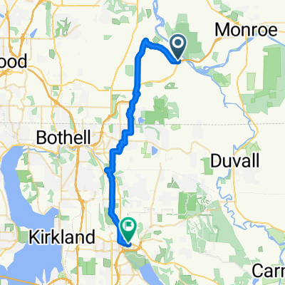
High Bridge Road 14500, Snohomish to High Bridge Road 14500, Snohomish
A cycling route starting in Cathcart, Washington, United States.
Overview
About this route
- 3 h 25 min
- Duration
- 61.8 km
- Distance
- 713 m
- Ascent
- 721 m
- Descent
- 18.1 km/h
- Avg. speed
- ---
- Max. altitude

Route quality
Waytypes & surfaces along the route
Waytypes
Road
33.4 km
(54 %)
Cycleway
7.4 km
(12 %)
Surfaces
Paved
16.1 km
(26 %)
Asphalt
11.1 km
(18 %)
Concrete
4.9 km
(8 %)
Undefined
45.8 km
(74 %)
Continue with Bikemap
Use, edit, or download this cycling route
You would like to ride High Bridge Road 14500, Snohomish to High Bridge Road 14500, Snohomish or customize it for your own trip? Here is what you can do with this Bikemap route:
Free features
- Save this route as favorite or in collections
- Copy & plan your own version of this route
- Sync your route with Garmin or Wahoo
Premium features
Free trial for 3 days, or one-time payment. More about Bikemap Premium.
- Navigate this route on iOS & Android
- Export a GPX / KML file of this route
- Create your custom printout (try it for free)
- Download this route for offline navigation
Discover more Premium features.
Get Bikemap PremiumFrom our community
Other popular routes starting in Cathcart
 Clearview-Monroe-Lord's Hill-Snohomish Loop
- Distance
- 46.8 km
- Ascent
- 416 m
- Descent
- 440 m
- Location
- Cathcart, Washington, United States
 SR522bridge-Redmond
- Distance
- 28.7 km
- Ascent
- 380 m
- Descent
- 393 m
- Location
- Cathcart, Washington, United States
 High Bridge Road 14500, Snohomish to High Bridge Road 14500, Snohomish
- Distance
- 61.8 km
- Ascent
- 713 m
- Descent
- 721 m
- Location
- Cathcart, Washington, United States
 SnoMo Tour
- Distance
- 54.2 km
- Ascent
- 235 m
- Descent
- 265 m
- Location
- Cathcart, Washington, United States
 16728 Broadway Ave, Snohomish to 13701–13723 174th Ave NE, Redmond
- Distance
- 19 km
- Ascent
- 254 m
- Descent
- 234 m
- Location
- Cathcart, Washington, United States
Open it in the app