

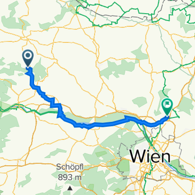
Overview
About this route
- -:--
- Duration
- 45.1 km
- Distance
- 346 m
- Ascent
- 346 m
- Descent
- ---
- Avg. speed
- ---
- Max. altitude

Part of
Gars
16 stages
Route quality
Waytypes & surfaces along the route
Waytypes
Road
16.7 km
(37 %)
Quiet road
10.4 km
(23 %)
Surfaces
Paved
28.4 km
(63 %)
Unpaved
0.9 km
(2 %)
Asphalt
27.5 km
(61 %)
Paved (undefined)
0.9 km
(2 %)
Continue with Bikemap
Use, edit, or download this cycling route
You would like to ride Gars-Eggenburg-Rosenburg-Gars or customize it for your own trip? Here is what you can do with this Bikemap route:
Free features
- Save this route as favorite or in collections
- Copy & plan your own version of this route
- Sync your route with Garmin or Wahoo
Premium features
Free trial for 3 days, or one-time payment. More about Bikemap Premium.
- Navigate this route on iOS & Android
- Export a GPX / KML file of this route
- Create your custom printout (try it for free)
- Download this route for offline navigation
Discover more Premium features.
Get Bikemap PremiumFrom our community
Other popular routes starting in Gars am Kamp
 KTM1
KTM1- Distance
- 56 km
- Ascent
- 1,290 m
- Descent
- 1,016 m
- Location
- Gars am Kamp, Lower Austria, Austria
 Ausfahrt von Stallegg nach Langenlois
- Distance
- 25.7 km
- Ascent
- 167 m
- Descent
- 225 m
- Location
- Gars am Kamp, Lower Austria, Austria
 Gars_Runde_2
- Distance
- 40.3 km
- Ascent
- 397 m
- Descent
- 397 m
- Location
- Gars am Kamp, Lower Austria, Austria
 Graslweg
- Distance
- 39.2 km
- Ascent
- 488 m
- Descent
- 489 m
- Location
- Gars am Kamp, Lower Austria, Austria
 Von Gars am Kamp nach Schönberg am Kamp
- Distance
- 14.4 km
- Ascent
- 256 m
- Descent
- 287 m
- Location
- Gars am Kamp, Lower Austria, Austria
 Kamptal
- Distance
- 35 km
- Ascent
- 250 m
- Descent
- 308 m
- Location
- Gars am Kamp, Lower Austria, Austria
 Stupa Irene 1
- Distance
- 90.1 km
- Ascent
- 340 m
- Descent
- 418 m
- Location
- Gars am Kamp, Lower Austria, Austria
 Kamptalweg Abschnitt D, Gars am Kamp nach Bahnhofplatz, Krems an der Donau
- Distance
- 50 km
- Ascent
- 474 m
- Descent
- 548 m
- Location
- Gars am Kamp, Lower Austria, Austria
Open it in the app