

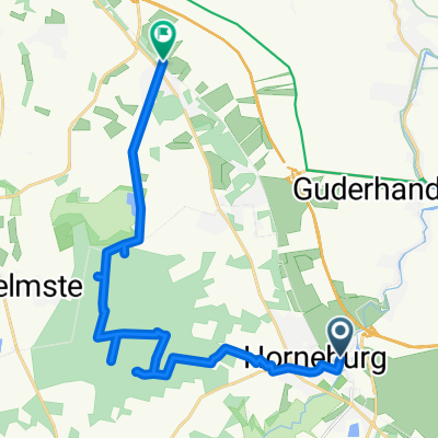
durch den Rüstjer forst
A cycling route starting in Horneburg, Lower Saxony, Germany.
Overview
About this route
hike here because wandermap does not work
- -:--
- Duration
- 16.8 km
- Distance
- 73 m
- Ascent
- 75 m
- Descent
- ---
- Avg. speed
- ---
- Max. altitude
Continue with Bikemap
Use, edit, or download this cycling route
You would like to ride durch den Rüstjer forst or customize it for your own trip? Here is what you can do with this Bikemap route:
Free features
- Save this route as favorite or in collections
- Copy & plan your own version of this route
- Sync your route with Garmin or Wahoo
Premium features
Free trial for 3 days, or one-time payment. More about Bikemap Premium.
- Navigate this route on iOS & Android
- Export a GPX / KML file of this route
- Create your custom printout (try it for free)
- Download this route for offline navigation
Discover more Premium features.
Get Bikemap PremiumFrom our community
Other popular routes starting in Horneburg
 Horneburg - Lüneburg
- Distance
- 89.7 km
- Ascent
- 478 m
- Descent
- 460 m
- Location
- Horneburg, Lower Saxony, Germany
 Elberundweg
- Distance
- 60.9 km
- Ascent
- 79 m
- Descent
- 79 m
- Location
- Horneburg, Lower Saxony, Germany
 Horneburg - Hamburg Hafenmuseum
- Distance
- 44.8 km
- Ascent
- 31 m
- Descent
- 32 m
- Location
- Horneburg, Lower Saxony, Germany
 Vorschlag
- Distance
- 60.4 km
- Ascent
- 156 m
- Descent
- 162 m
- Location
- Horneburg, Lower Saxony, Germany
 03.10.2016 mit Gerd und Rene
- Distance
- 59.8 km
- Ascent
- 153 m
- Descent
- 154 m
- Location
- Horneburg, Lower Saxony, Germany
 Sonntag
- Distance
- 62 km
- Ascent
- 15 m
- Descent
- 17 m
- Location
- Horneburg, Lower Saxony, Germany
 BELMONDO > Neuenfelde
- Distance
- 21.8 km
- Ascent
- 23 m
- Descent
- 29 m
- Location
- Horneburg, Lower Saxony, Germany
 durch den Rüstjer forst
- Distance
- 16.8 km
- Ascent
- 73 m
- Descent
- 75 m
- Location
- Horneburg, Lower Saxony, Germany
Open it in the app