
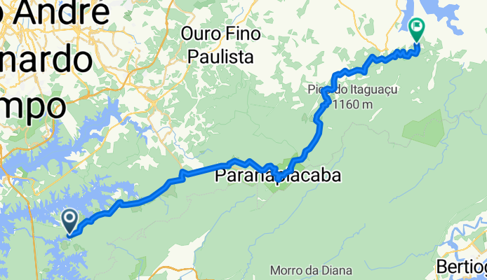
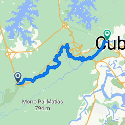
SBC - MOGI
A cycling route starting in Cubatão, São Paulo, Brazil.
Overview
About this route
- -:--
- Duration
- 47.9 km
- Distance
- 498 m
- Ascent
- 455 m
- Descent
- ---
- Avg. speed
- 937 m
- Max. altitude

Route quality
Waytypes & surfaces along the route
Waytypes
Quiet road
25.1 km
(52 %)
Road
18.6 km
(39 %)
Surfaces
Paved
9.6 km
(20 %)
Unpaved
35.1 km
(73 %)
Ground
22.7 km
(47 %)
Unpaved (undefined)
12.4 km
(26 %)
Route highlights
Points of interest along the route
Photo after 2.3 km
Sangradouro do Perequê
Point of interest after 4.5 km
Haras
Point of interest after 6.9 km
7 Tubos
Point of interest after 8 km
Poço
Point of interest after 9.4 km
Riozinho Caminho do Sal
Photo after 9.7 km
Mirante
Point of interest after 10.3 km
Trilha do Cachorro Louco
Point of interest after 12.2 km
Caminho Lago do Cristal
Point of interest after 13 km
Fim Zanzala Inicio Carvoeiros
Point of interest after 14.8 km
Trilha cachoeira da Fumaça
Point of interest after 15.1 km
Solvay
Drinking water after 17.3 km
Alimentação
Point of interest after 20.9 km
Apiário
Point of interest after 21.8 km
Trilha Paranapiacaba Baixa
Point of interest after 22.5 km
Trilha da Pontinha
Drinking water after 23.6 km
Fonte de Água
Point of interest after 23.7 km
Fim Carvoeiros Inicio Bento Ponteiro
Point of interest after 24.8 km
Trilha da Pontinha
Point of interest after 27.8 km
Igreja Taquarussu
Point of interest after 31.2 km
Pesqueiro
Point of interest after 37 km
Saída para Palmeiras de Suzano à esquerda via Rodovia Koyama
Point of interest after 37.5 km
Furnas
Point of interest after 38.5 km
Quatingua Mercado
Continue with Bikemap
Use, edit, or download this cycling route
You would like to ride SBC - MOGI or customize it for your own trip? Here is what you can do with this Bikemap route:
Free features
- Save this route as favorite or in collections
- Copy & plan your own version of this route
- Sync your route with Garmin or Wahoo
Premium features
Free trial for 3 days, or one-time payment. More about Bikemap Premium.
- Navigate this route on iOS & Android
- Export a GPX / KML file of this route
- Create your custom printout (try it for free)
- Download this route for offline navigation
Discover more Premium features.
Get Bikemap PremiumFrom our community
Other popular routes starting in Cubatão
 SBC - MOGI
- Distance
- 47.9 km
- Ascent
- 498 m
- Descent
- 455 m
- Location
- Cubatão, São Paulo, Brazil
 Fabril
- Distance
- 16.4 km
- Ascent
- 121 m
- Descent
- 120 m
- Location
- Cubatão, São Paulo, Brazil
 Trilha Rio do Ouro
- Distance
- 7.3 km
- Ascent
- 71 m
- Descent
- 106 m
- Location
- Cubatão, São Paulo, Brazil
 Rota: Imigrantes > Curucutu > Evangelista
- Distance
- 21.2 km
- Ascent
- 286 m
- Descent
- 330 m
- Location
- Cubatão, São Paulo, Brazil
 Estrada de manutenção da imigrantes
- Distance
- 21.6 km
- Ascent
- 230 m
- Descent
- 940 m
- Location
- Cubatão, São Paulo, Brazil
 Caminho do Mar Circular - cachoeira torre
- Distance
- 39.4 km
- Ascent
- 221 m
- Descent
- 222 m
- Location
- Cubatão, São Paulo, Brazil
 Rota Caminho do Sal
- Distance
- 47.3 km
- Ascent
- 524 m
- Descent
- 471 m
- Location
- Cubatão, São Paulo, Brazil
 Serra do Mar - Gasoduto - Estrada Velha de Santos a Paranapiacaba
- Distance
- 21.1 km
- Ascent
- 268 m
- Descent
- 156 m
- Location
- Cubatão, São Paulo, Brazil
Open it in the app