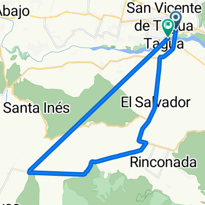
De Lago Panguipulli 706, San Vicente de Taguatagua a Lago Panguipulli 705, San Vicente de Taguatagua
A cycling route starting in San Vicente de Tagua Tagua, O'Higgins Region, Chile.
Overview
About this route
- 1 h 14 min
- Duration
- 26.5 km
- Distance
- 132 m
- Ascent
- 123 m
- Descent
- 21.6 km/h
- Avg. speed
- ---
- Max. altitude
Route quality
Waytypes & surfaces along the route
Waytypes
Living street
1.1 km
(4 %)
Road
0.8 km
(3 %)
Surfaces
Paved
25.5 km
(96 %)
Paved (undefined)
24.4 km
(92 %)
Asphalt
1.1 km
(4 %)
Undefined
1.1 km
(4 %)
Continue with Bikemap
Use, edit, or download this cycling route
You would like to ride De Lago Panguipulli 706, San Vicente de Taguatagua a Lago Panguipulli 705, San Vicente de Taguatagua or customize it for your own trip? Here is what you can do with this Bikemap route:
Free features
- Save this route as favorite or in collections
- Copy & plan your own version of this route
- Sync your route with Garmin or Wahoo
Premium features
Free trial for 3 days, or one-time payment. More about Bikemap Premium.
- Navigate this route on iOS & Android
- Export a GPX / KML file of this route
- Create your custom printout (try it for free)
- Download this route for offline navigation
Discover more Premium features.
Get Bikemap PremiumFrom our community
Other popular routes starting in San Vicente de Tagua Tagua
- De Avenida España 290, San Vicente de Taguatagua a Capitan Arturo Prat Chacon 207, Cachapoal
- Distance
- 19.6 km
- Ascent
- 174 m
- Descent
- 186 m
- Location
- San Vicente de Tagua Tagua, O'Higgins Region, Chile
- Paseito por Sta.Ines-Antivero-El Tambo
- Distance
- 16.5 km
- Ascent
- 71 m
- Descent
- 72 m
- Location
- San Vicente de Tagua Tagua, O'Higgins Region, Chile
- Rally San Vicente XCM 2013
- Distance
- 53.8 km
- Ascent
- 866 m
- Descent
- 865 m
- Location
- San Vicente de Tagua Tagua, O'Higgins Region, Chile
- De Callejón Tiralarga 54, San Vicente de Taguatagua a Francia 1119, San Vicente de Taguatagua
- Distance
- 20.3 km
- Ascent
- 106 m
- Descent
- 109 m
- Location
- San Vicente de Tagua Tagua, O'Higgins Region, Chile
- De Lago Panguipulli 706, San Vicente de Taguatagua a Lago Panguipulli 705, San Vicente de Taguatagua
- Distance
- 26.5 km
- Ascent
- 132 m
- Descent
- 123 m
- Location
- San Vicente de Tagua Tagua, O'Higgins Region, Chile
- Raquegua a Ruta 66
- Distance
- 27.6 km
- Ascent
- 1 m
- Descent
- 1 m
- Location
- San Vicente de Tagua Tagua, O'Higgins Region, Chile
- 11)Salsipuedes-Angol
- Distance
- 622.1 km
- Ascent
- 1,652 m
- Descent
- 1,837 m
- Location
- San Vicente de Tagua Tagua, O'Higgins Region, Chile
- probando app
- Distance
- 24.7 km
- Ascent
- 901 m
- Descent
- 899 m
- Location
- San Vicente de Tagua Tagua, O'Higgins Region, Chile
Open it in the app