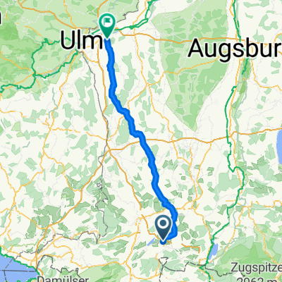
Wertach Radweg ab Oy
A cycling route starting in Oy-Mittelberg, Bavaria, Germany.
Overview
About this route
Der Fernradweg "Wertach erleben" verlĂ€uft entlang des Flusses vom Ursprung bis zur MĂŒndung ĂŒber eine Strecke von ca. 145 km von Oberjoch bis Augsburg. Die Wertach, der zweitlĂ€ngste Fluss im AllgĂ€u, entspringt aus zwei kleinen BĂ€chen in Oberjoch. (Tourbeschreibung unter: thod_er@gmx.de)
- -:--
- Duration
- 139.9 km
- Distance
- 316 m
- Ascent
- 734 m
- Descent
- ---
- Avg. speed
- ---
- Max. altitude
Route quality
Waytypes & surfaces along the route
Waytypes
Track
57.8 km
(41 %)
Quiet road
39.3 km
(28 %)
Surfaces
Paved
49.4 km
(35 %)
Unpaved
62.9 km
(45 %)
Asphalt
37.8 km
(27 %)
Gravel
35.3 km
(25 %)
Continue with Bikemap
Use, edit, or download this cycling route
You would like to ride Wertach Radweg ab Oy or customize it for your own trip? Here is what you can do with this Bikemap route:
Free features
- Save this route as favorite or in collections
- Copy & plan your own version of this route
- Split it into stages to create a multi-day tour
- Sync your route with Garmin or Wahoo
Premium features
Free trial for 3 days, or one-time payment. More about Bikemap Premium.
- Navigate this route on iOS & Android
- Export a GPX / KML file of this route
- Create your custom printout (try it for free)
- Download this route for offline navigation
Discover more Premium features.
Get Bikemap PremiumFrom our community
Other popular routes starting in Oy-Mittelberg
- Oy Mittelberg - 12 Seentour, AllgÀu (Deutschland)
- Distance
- 49.7 km
- Ascent
- 739 m
- Descent
- 740 m
- Location
- Oy-Mittelberg, Bavaria, Germany
- Tour der Lukas
- Distance
- 81.6 km
- Ascent
- 1,651 m
- Descent
- 2,005 m
- Location
- Oy-Mittelberg, Bavaria, Germany
- GrĂŒntensee
- Distance
- 35.5 km
- Ascent
- 787 m
- Descent
- 774 m
- Location
- Oy-Mittelberg, Bavaria, Germany
- Oy Mittelberg - Rottachseetour, AllgÀu (Deutschland)
- Distance
- 27.3 km
- Ascent
- 388 m
- Descent
- 390 m
- Location
- Oy-Mittelberg, Bavaria, Germany
- Rennradrunde Mittelberg-KönigsstrĂ€Ăchen-Hinterstein-Oberjoch-Wertach
- Distance
- 95.4 km
- Ascent
- 1,462 m
- Descent
- 1,461 m
- Location
- Oy-Mittelberg, Bavaria, Germany
- GrĂŒntensee-Tannheimer Tal-Pfronten-GrĂŒntensee
- Distance
- 55 km
- Ascent
- 871 m
- Descent
- 860 m
- Location
- Oy-Mittelberg, Bavaria, Germany
- Mountenbikerunde Wertach-Tannheimer Tal - Achtal - Wertach
- Distance
- 58.3 km
- Ascent
- 596 m
- Descent
- 596 m
- Location
- Oy-Mittelberg, Bavaria, Germany
- GrĂŒntensee - Haldensee
- Distance
- 55.2 km
- Ascent
- 509 m
- Descent
- 509 m
- Location
- Oy-Mittelberg, Bavaria, Germany
Open it in the app