

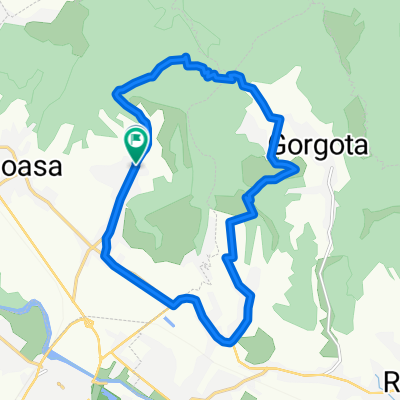
Viforata MTB Green 34 km Mnst. Viforata - Pd. Gorgota - Glodeni - La Releu - Pd. Aninoasa - Viforata (ADE 130)
A cycling route starting in Viforâta, Dâmbovița County, Romania.
Overview
About this route
Route Length - 34 km. Offroad / gravel road - 29 km; asphalt / concrete slabs - 5 km
*** description, map & photos by FB page "Green trails MTB outdoor-fun"
Duration: 7h30m in my case, moderate pace with frequent breaks admiring landscapes, photos, visiting the monasteries Gorgota and Viforata, lunch break
The tour took place in May 2021. Bike type: MTB XC hardtail (not an E-bike)
My favorites: --- the descent and the forest between km 2 - 4.6; --- the trail and the forest between km 29.5 - 33.8; --- the viewpoint La Releu; --- the viewpoint Poiana Aninoasa; --- the descent between km 9 - 11; --- the descent between km 22.3 - 25
A complex bike trip very mountainous - with several ascents (some challenging) and descents, with beautiful landscapes and viewpoints, extensive forests, villages strung between hills.
The tour begins with a climb of approx. 2 km through the Aninoasa forest on the modernized gravel road, after which we continued to the right on a 2.6 km section until the edge of the village of Gorgota - composed of two cool descents - the first on gravel road, the second on a very flowy forest path (interrupted by a flat section of about 900 m).
From the edge of the village followed a nice trail of about 2.4 km in the Gorgota forest - at km 6.3 there was a sector of about 80 m a bit muddy followed by about 150 m of climbing on an uncyclable stretch of road where I pulled the bike beside me, after which I followed the dirt road that led into the village. At km 8 there followed 1 km of climbing on asphalt, the slope being quite challenging - at the end of the climb was the Gorgota monastery, an appropriate occasion to visit it. There follows a full-speed descent of 2 km with nice views of the village situated between hills, the journey continuing on gravel road.
At km 15.2 there followed a climb of about 1.2 km, also quite challenging - up to the point where we entered onto asphalt in the village of Malu Mierii, rewarded with a descent of 1.4 km. The road continues with a roller-coaster on asphalt until the village of Gusoiu, at the edge of which begins at km 20, on a grassy country road the climb towards the viewpoint La Releu. A challenging ascent of 2.3 km in which I also had to do a lot of push-bike, the views with the villages left behind and the tall mountains in the distance making me forget about the climb - from La Releu (I made a small detour towards this peak; the views and thick grass here signaled me that it was time to rest and snack on the sandwiches from my backpack) followed a simply great descent of 2.7 km down to the village of Aninoasa.
After a walk on asphalt through the village, we returned up on the hills with a climb of approx. 650 m - this was also quite demanding with push-bike included, making a detour towards the meadow Aninoasa - one of my favorite places on the route - and also a viewpoint. I returned on the modernized gravel road that crosses the Aninoasa forest towards Viforata, from km 29.9 also followed the last ascent of the trip - of about 1.3 km of which the first 600 m I traveled on the very flowy trail that goes through the coolness of the forest parallel to the gravel road - followed by a full-speed descent of 2.5 km back to the place where I started the tour.
Car access. From Bucharest I drove on the DN 7 to Tartasesti, from where I continued on the DN 71 to Targoviste at the crossing of the Ialomita river (a little after the roundabout in front of the Lukoil gas station on Gimnaziului street) - where the DN 71 intersects with DJ 719. From here we continued on DJ 719 to the village of Valea Voievozilor, where I turned left onto DN 72, and after about 2.5 km I continued to the right on DJ 717 for 1.8 km, from where I continued to the right on DJ 718 to the Viforata Monastery.
Have fun :)
- -:--
- Duration
- 33.8 km
- Distance
- 1,075 m
- Ascent
- 1,073 m
- Descent
- ---
- Avg. speed
- 489 m
- Max. altitude

Route photos
\"")
\"")
\"")
\"")
\"")
\"")
\"")
\"")
Continue with Bikemap
Use, edit, or download this cycling route
You would like to ride Viforata MTB Green 34 km Mnst. Viforata - Pd. Gorgota - Glodeni - La Releu - Pd. Aninoasa - Viforata (ADE 130) or customize it for your own trip? Here is what you can do with this Bikemap route:
Free features
- Save this route as favorite or in collections
- Copy & plan your own version of this route
- Sync your route with Garmin or Wahoo
Premium features
Free trial for 3 days, or one-time payment. More about Bikemap Premium.
- Navigate this route on iOS & Android
- Export a GPX / KML file of this route
- Create your custom printout (try it for free)
- Download this route for offline navigation
Discover more Premium features.
Get Bikemap PremiumFrom our community
Other popular routes starting in Viforâta
 Viforata MTB Green 34 km Mnst. Viforata - Pd. Gorgota - Glodeni - La Releu - Pd. Aninoasa - Viforata (ADE 130)
- Distance
- 33.8 km
- Ascent
- 1,075 m
- Descent
- 1,073 m
- Location
- Viforâta, Dâmbovița County, Romania
 First bike track through Tirgoviste hills
- Distance
- 16.4 km
- Ascent
- 342 m
- Descent
- 342 m
- Location
- Viforâta, Dâmbovița County, Romania
 targoviste - pucioasa
- Distance
- 18.5 km
- Ascent
- 118 m
- Descent
- 0 m
- Location
- Viforâta, Dâmbovița County, Romania
 Grat route accross Hills near Targoviste
- Distance
- 16.5 km
- Ascent
- 311 m
- Descent
- 311 m
- Location
- Viforâta, Dâmbovița County, Romania
 Targoviste-Manastirea Bunea-Targoviste
- Distance
- 46.7 km
- Ascent
- 361 m
- Descent
- 362 m
- Location
- Viforâta, Dâmbovița County, Romania
 pucioasa
- Distance
- 72.5 km
- Ascent
- 346 m
- Descent
- 344 m
- Location
- Viforâta, Dâmbovița County, Romania
 Birou - Manastirea Viforata - Aninoasa
- Distance
- 11.7 km
- Ascent
- 190 m
- Descent
- 187 m
- Location
- Viforâta, Dâmbovița County, Romania
 Viforata-Gorgota-Aninoasa
- Distance
- 31.9 km
- Ascent
- 704 m
- Descent
- 701 m
- Location
- Viforâta, Dâmbovița County, Romania
Open it in the app