

Mühltal
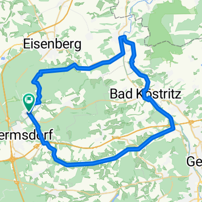
A cycling route starting in Bad Klosterlausnitz, Free State of Thuringia, Germany.
Overview
About this route
Klosterlausnitz - Crossen über Mühltal Es geht entlang der Rauda immer schön durch den grünen Grund. Die Strecke ist reichhaltig mit Gaststätten versehen und weitgehend frisch asphaltiert. Autoverkehr hält sich in Grenzen. Am WE viele Fußgänger.
- -:--
- Duration
- 14.8 km
- Distance
- 63 m
- Ascent
- 200 m
- Descent
- ---
- Avg. speed
- 320 m
- Avg. speed
Route quality
Waytypes & surfaces along the route
Waytypes
Quiet road
7.7 km
(52 %)
Track
2.1 km
(14 %)
Surfaces
Paved
10.8 km
(73 %)
Unpaved
2.1 km
(14 %)
Asphalt
9.3 km
(63 %)
Ground
1.1 km
(8 %)
Continue with Bikemap
Use, edit, or download this cycling route
You would like to ride Mühltal or customize it for your own trip? Here is what you can do with this Bikemap route:
Free features
- Save this route as favorite or in collections
- Copy & plan your own version of this route
- Sync your route with Garmin or Wahoo
Premium features
Free trial for 3 days, or one-time payment. More about Bikemap Premium.
- Navigate this route on iOS & Android
- Export a GPX / KML file of this route
- Create your custom printout (try it for free)
- Download this route for offline navigation
Discover more Premium features.
Get Bikemap PremiumFrom our community
Other popular routes starting in Bad Klosterlausnitz
 BAd Klosterlausnitz - Chemnitz
- Distance
- 109.9 km
- Ascent
- 523 m
- Descent
- 547 m
- Location
- Bad Klosterlausnitz, Free State of Thuringia, Germany
 BadK-Gera Elsterradweg-Hartmannsdorf-Mühltahl
- Distance
- 52 km
- Ascent
- 308 m
- Descent
- 308 m
- Location
- Bad Klosterlausnitz, Free State of Thuringia, Germany
 Tag 3 Tour 2023
- Distance
- 61.5 km
- Ascent
- 379 m
- Descent
- 437 m
- Location
- Bad Klosterlausnitz, Free State of Thuringia, Germany
 Bad Klosterlausnick - Jena -Bad Klosterlausnick
- Distance
- 52.8 km
- Ascent
- 625 m
- Descent
- 624 m
- Location
- Bad Klosterlausnitz, Free State of Thuringia, Germany
 Bad Klosterlausnitz- Köstritz-Gera
- Distance
- 50.5 km
- Ascent
- 333 m
- Descent
- 333 m
- Location
- Bad Klosterlausnitz, Free State of Thuringia, Germany
 Neue Straße 25, Bad Klosterlausnitz nach Neue Straße 23, Bad Klosterlausnitz
- Distance
- 14.1 km
- Ascent
- 215 m
- Descent
- 215 m
- Location
- Bad Klosterlausnitz, Free State of Thuringia, Germany
 Mühltalrunde
- Distance
- 43.5 km
- Ascent
- 255 m
- Descent
- 255 m
- Location
- Bad Klosterlausnitz, Free State of Thuringia, Germany
 5. Tag Bad Klosterlausnitz -Chemnitz
- Distance
- 98.3 km
- Ascent
- 594 m
- Descent
- 604 m
- Location
- Bad Klosterlausnitz, Free State of Thuringia, Germany
Open it in the app