

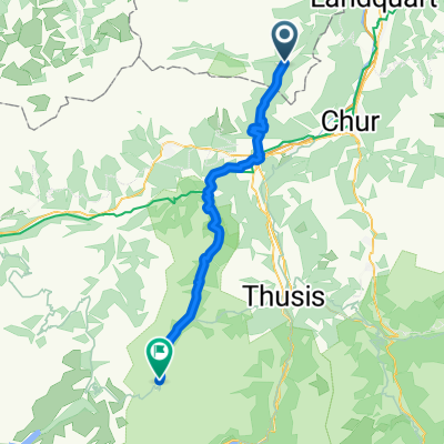
Untervaz-Kunkels-Pfäfers-Untervaz
A cycling route starting in Untervaz, Grisons, Switzerland.
Overview
About this route
The more you write here, the more helpful it is for other users.* Route course.* Why do you like this route?* Why do you recommend it?* What are the highlights?* etc.
- -:--
- Duration
- 58.4 km
- Distance
- 952 m
- Ascent
- 952 m
- Descent
- ---
- Avg. speed
- ---
- Max. altitude
Continue with Bikemap
Use, edit, or download this cycling route
You would like to ride Untervaz-Kunkels-Pfäfers-Untervaz or customize it for your own trip? Here is what you can do with this Bikemap route:
Free features
- Save this route as favorite or in collections
- Copy & plan your own version of this route
- Sync your route with Garmin or Wahoo
Premium features
Free trial for 3 days, or one-time payment. More about Bikemap Premium.
- Navigate this route on iOS & Android
- Export a GPX / KML file of this route
- Create your custom printout (try it for free)
- Download this route for offline navigation
Discover more Premium features.
Get Bikemap PremiumFrom our community
Other popular routes starting in Untervaz
 Landquart Runde
- Distance
- 18.2 km
- Ascent
- 126 m
- Descent
- 126 m
- Location
- Untervaz, Grisons, Switzerland
 Untervaz-Mastrils-Untervaz
- Distance
- 12.4 km
- Ascent
- 710 m
- Descent
- 725 m
- Location
- Untervaz, Grisons, Switzerland
 Bawangs 7, Untervaz nach Im Hof 1, Bilten
- Distance
- 60.8 km
- Ascent
- 890 m
- Descent
- 996 m
- Location
- Untervaz, Grisons, Switzerland
 Alpencross_2015_vaettis_tiefencaTag4
- Distance
- 46.2 km
- Ascent
- 1,253 m
- Descent
- 1,356 m
- Location
- Untervaz, Grisons, Switzerland
 Untervaz Alp Salaz St Margr. Taminatal calfeisental Kunkelspass Chur
- Distance
- 73.3 km
- Ascent
- 3,205 m
- Descent
- 3,194 m
- Location
- Untervaz, Grisons, Switzerland
 17-3-AC-d
- Distance
- 45.9 km
- Ascent
- 1,640 m
- Descent
- 888 m
- Location
- Untervaz, Grisons, Switzerland
 17-3-AC-c
- Distance
- 47.6 km
- Ascent
- 1,634 m
- Descent
- 883 m
- Location
- Untervaz, Grisons, Switzerland
 17-3-AC-e
- Distance
- 54.1 km
- Ascent
- 2,455 m
- Descent
- 1,703 m
- Location
- Untervaz, Grisons, Switzerland
Open it in the app