
Winzer-Radrundweg
A cycling route starting in Insheim, Rhineland-Palatinate, Germany.
Overview
About this route
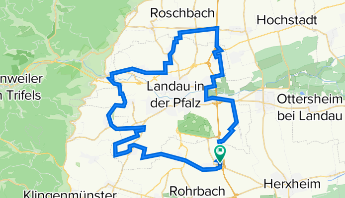
Auf insgesamt rund 43 Kilometern führt der Winzer-Radrundweg durch Landau, vor allem aber durch 13 pittoreske Winzerdörfer und Weinberge.
- -:--
- Duration
- 43.1 km
- Distance
- 297 m
- Ascent
- 297 m
- Descent
- ---
- Avg. speed
- ---
- Avg. speed

Route quality
Waytypes & surfaces along the route
Waytypes
Track
19 km
(44 %)
Quiet road
17.3 km
(40 %)
Surfaces
Paved
38 km
(88 %)
Unpaved
1 km
(2 %)
Asphalt
27.2 km
(63 %)
Paved (undefined)
6.6 km
(15 %)
Continue with Bikemap
Use, edit, or download this cycling route
You would like to ride Winzer-Radrundweg or customize it for your own trip? Here is what you can do with this Bikemap route:
Free features
- Save this route as favorite or in collections
- Copy & plan your own version of this route
- Sync your route with Garmin or Wahoo
Premium features
Free trial for 3 days, or one-time payment. More about Bikemap Premium.
- Navigate this route on iOS & Android
- Export a GPX / KML file of this route
- Create your custom printout (try it for free)
- Download this route for offline navigation
Discover more Premium features.
Get Bikemap PremiumFrom our community
Other popular routes starting in Insheim
 Winzer-Radrundweg
- Distance
- 43.1 km
- Ascent
- 297 m
- Descent
- 297 m
- Location
- Insheim, Rhineland-Palatinate, Germany
 Auf der Stirn 3, Insheim nach Untere Hauptstraße 103-105, Herxheim bei Landau (Pfalz)
- Distance
- 644.6 km
- Ascent
- 2,004 m
- Descent
- 1,817 m
- Location
- Insheim, Rhineland-Palatinate, Germany
 Sandweg 11, Insheim nach Schillerstraße 13, Westheim(Pfalz)
- Distance
- 19.3 km
- Ascent
- 51 m
- Descent
- 72 m
- Location
- Insheim, Rhineland-Palatinate, Germany
 Bergzabern-Tour
- Distance
- 40.1 km
- Ascent
- 131 m
- Descent
- 131 m
- Location
- Insheim, Rhineland-Palatinate, Germany
 Kneipp-Tour Bergzaberner Land
- Distance
- 49.8 km
- Ascent
- 188 m
- Descent
- 188 m
- Location
- Insheim, Rhineland-Palatinate, Germany
 Wissembourg
- Distance
- 86.7 km
- Ascent
- 278 m
- Descent
- 283 m
- Location
- Insheim, Rhineland-Palatinate, Germany
 Herxheim bei Landau (Pfalz) nach Birkenstraße 29, Landau in der Pfalz
- Distance
- 11.1 km
- Ascent
- 7 m
- Descent
- 0 m
- Location
- Insheim, Rhineland-Palatinate, Germany
 Auf dem Single Trail durch den Bienwalder Bärlauchwald - Start in Kandel, Tourende in Insheim/Landau
- Distance
- 34.8 km
- Ascent
- 210 m
- Descent
- 234 m
- Location
- Insheim, Rhineland-Palatinate, Germany
Open it in the app