
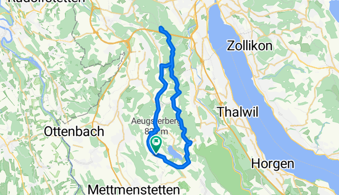
Dorfstrasse 29, Aeugst am Albis nach Dorfstrasse 29, Aeugst am Albis
A cycling route starting in Affoltern / Sonnenberg, Canton of Zurich, Switzerland.
Overview
About this route
- 1 h 56 min
- Duration
- 28.7 km
- Distance
- 776 m
- Ascent
- 773 m
- Descent
- 14.8 km/h
- Avg. speed
- ---
- Max. altitude
Route quality
Waytypes & surfaces along the route
Waytypes
Track
13.8 km
(48 %)
Path
4.9 km
(17 %)
Surfaces
Paved
14.4 km
(50 %)
Unpaved
10.7 km
(37 %)
Asphalt
11.7 km
(41 %)
Gravel
10.4 km
(36 %)
Continue with Bikemap
Use, edit, or download this cycling route
You would like to ride Dorfstrasse 29, Aeugst am Albis nach Dorfstrasse 29, Aeugst am Albis or customize it for your own trip? Here is what you can do with this Bikemap route:
Free features
- Save this route as favorite or in collections
- Copy & plan your own version of this route
- Sync your route with Garmin or Wahoo
Premium features
Free trial for 3 days, or one-time payment. More about Bikemap Premium.
- Navigate this route on iOS & Android
- Export a GPX / KML file of this route
- Create your custom printout (try it for free)
- Download this route for offline navigation
Discover more Premium features.
Get Bikemap PremiumFrom our community
Other popular routes starting in Affoltern / Sonnenberg
 Islisberg Abendrunde
- Distance
- 23.5 km
- Ascent
- 397 m
- Descent
- 407 m
- Location
- Affoltern / Sonnenberg, Canton of Zurich, Switzerland
 Actual Affoltern - Uetlihof
- Distance
- 20.4 km
- Ascent
- 290 m
- Descent
- 352 m
- Location
- Affoltern / Sonnenberg, Canton of Zurich, Switzerland
 Affoltern a.A./Türlersee
- Distance
- 15.7 km
- Ascent
- 282 m
- Descent
- 283 m
- Location
- Affoltern / Sonnenberg, Canton of Zurich, Switzerland
 ride through Zurich
- Distance
- 22.5 km
- Ascent
- 247 m
- Descent
- 458 m
- Location
- Affoltern / Sonnenberg, Canton of Zurich, Switzerland
 Höchweg 34, Aeugstertal nach Aeugstertal
- Distance
- 4 km
- Ascent
- 345 m
- Descent
- 199 m
- Location
- Affoltern / Sonnenberg, Canton of Zurich, Switzerland
 Affoltern am Albis - Ibergeregg
- Distance
- 117.6 km
- Ascent
- 1,456 m
- Descent
- 1,456 m
- Location
- Affoltern / Sonnenberg, Canton of Zurich, Switzerland
 Affoltern bis Zugerberg
- Distance
- 29 km
- Ascent
- 662 m
- Descent
- 222 m
- Location
- Affoltern / Sonnenberg, Canton of Zurich, Switzerland
 felsenegg - cross
- Distance
- 18.1 km
- Ascent
- 465 m
- Descent
- 466 m
- Location
- Affoltern / Sonnenberg, Canton of Zurich, Switzerland
Open it in the app