Overview
About this route
Turul la Sirnea cu bicicletele electrice este un tur de dificultate medie. Se merge pe asfalt, drum forestier si poteci.
Muntii Bucegi si Piatra Craiului ofera un peisaj de vis care este completat de satul Sirnea in toata splendoarea lui.
Durata traseu, aproximativ 3-4 ore cu pauze pentru hidratare si fotografie. Dificultatea este medie.
- -:--
- Duration
- 20.7 km
- Distance
- 502 m
- Ascent
- 502 m
- Descent
- ---
- Avg. speed
- ---
- Max. altitude
Part of

7 stages
Route quality
Waytypes & surfaces along the route
Waytypes
Cycleway
6.6 km
(32 %)
Track
5 km
(24 %)
Surfaces
Paved
11.4 km
(55 %)
Unpaved
5.2 km
(25 %)
Asphalt
11.4 km
(55 %)
Gravel
2.7 km
(13 %)
Continue with Bikemap
Use, edit, or download this cycling route
You would like to ride Ocol ebike Sirnea or customize it for your own trip? Here is what you can do with this Bikemap route:
Free features
- Save this route as favorite or in collections
- Copy & plan your own version of this route
- Sync your route with Garmin or Wahoo
Premium features
Free trial for 3 days, or one-time payment. More about Bikemap Premium.
- Navigate this route on iOS & Android
- Export a GPX / KML file of this route
- Create your custom printout (try it for free)
- Download this route for offline navigation
Discover more Premium features.
Get Bikemap PremiumFrom our community
Other popular routes starting in Moeciu de Jos
- Tur Cheile Dambovicioarei
- Distance
- 42.8 km
- Ascent
- 902 m
- Descent
- 902 m
- Location
- Moeciu de Jos, BraČov County, Romania
- Pestera - Magura - Moieciu de Jos - Pestera (inspirat din 146626)
- Distance
- 18.6 km
- Ascent
- 513 m
- Descent
- 507 m
- Location
- Moeciu de Jos, BraČov County, Romania
- PeČtera to PeČtera
- Distance
- 16.4 km
- Ascent
- 566 m
- Descent
- 488 m
- Location
- Moeciu de Jos, BraČov County, Romania
- Tur Sirnea
- Distance
- 17.7 km
- Ascent
- 392 m
- Descent
- 395 m
- Location
- Moeciu de Jos, BraČov County, Romania
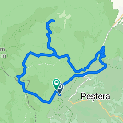
- Casa Folea - Magura - cab Curmatura - Valea Prapastiilor - La Table - Valea Pietrelor - Casa Folea
- Distance
- 24.3 km
- Ascent
- 964 m
- Descent
- 880 m
- Location
- Moeciu de Jos, BraČov County, Romania
- PeČtera (Nobilis) - MÄgura - Moieciu de Jos (Hanul cu Noroc)
- Distance
- 11.9 km
- Ascent
- 93 m
- Descent
- 493 m
- Location
- Moeciu de Jos, BraČov County, Romania
- propunere 2 moeciu-sosea-sirnea-pestera
- Distance
- 25.6 km
- Ascent
- 698 m
- Descent
- 696 m
- Location
- Moeciu de Jos, BraČov County, Romania
- Moieciu Jos - Amfiteatru Transilvania - Moieciu Sus - Cheile Gradistei - Fundata - Fundatica - Moieciu Sus - Moieciu Jos
- Distance
- 36.1 km
- Ascent
- 1,092 m
- Descent
- 1,091 m
- Location
- Moeciu de Jos, BraČov County, Romania
Open it in the app