

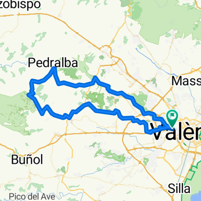
Quart-Chirivilla-Quart
A cycling route starting in Quart de Poblet, Valencia, Spain.
Overview
About this route
A nice route from home, be careful in the Betera-Olocau section because the 'bike lane' is a constant dizzy spell forcing us to cross through the middle of the road, which I find much more dangerous than riding by the shoulder normally. I see the bike lane as appropriate for a large group of cyclists, which does hinder drivers, but a lone cyclist crossing the road side to side with their racing bike is almost invisible to a car that comes 'zooming' or simply distracted. That said, it must also be noted that once we reach Olocau and begin the ascent to Alto Chirivilla, the only traffic we will encounter will be cyclists (very much appreciated). It’s about 16 km of very irregular ascent from Olocau, which doesn’t allow us to take a clear pace and ends up feeling long, especially the most demanding section, which we will have from Gatova until we reach the summit at 710 m already in the province of Castellón. The descent to Betera can be dizzying, on a day with a tailwind or simply no wind, in the Olocau-Betera section, you fly.
- -:--
- Duration
- 95.4 km
- Distance
- 758 m
- Ascent
- 758 m
- Descent
- ---
- Avg. speed
- ---
- Max. altitude

Continue with Bikemap
Use, edit, or download this cycling route
You would like to ride Quart-Chirivilla-Quart or customize it for your own trip? Here is what you can do with this Bikemap route:
Free features
- Save this route as favorite or in collections
- Copy & plan your own version of this route
- Split it into stages to create a multi-day tour
- Sync your route with Garmin or Wahoo
Premium features
Free trial for 3 days, or one-time payment. More about Bikemap Premium.
- Navigate this route on iOS & Android
- Export a GPX / KML file of this route
- Create your custom printout (try it for free)
- Download this route for offline navigation
Discover more Premium features.
Get Bikemap PremiumFrom our community
Other popular routes starting in Quart de Poblet
 De Calle de la Senda 6, Cuart de Poblet a Carrer de Ramón y Cajal 8B, Montserrat
- Distance
- 29.9 km
- Ascent
- 327 m
- Descent
- 184 m
- Location
- Quart de Poblet, Valencia, Spain
 Río Turia, Quart de Poblet, La Pea
- Distance
- 29.1 km
- Ascent
- 10 m
- Descent
- 10 m
- Location
- Quart de Poblet, Valencia, Spain
 Quart-Chirivilla-Quart
- Distance
- 95.4 km
- Ascent
- 758 m
- Descent
- 758 m
- Location
- Quart de Poblet, Valencia, Spain
 De Avinguda Reial Monestir Santa Maria de Poblet 18, Quart de Poblet a Carretera d'Alba, Valencia
- Distance
- 7.6 km
- Ascent
- 36 m
- Descent
- 47 m
- Location
- Quart de Poblet, Valencia, Spain
 LA PORTERA-VTA GAETA
- Distance
- 178.9 km
- Ascent
- 1,107 m
- Descent
- 1,113 m
- Location
- Quart de Poblet, Valencia, Spain
 Mislata-Fluvial-Villamarxant-Pedralba-Tramo Cabriel-Xest-Carasoles-Manises-Mislata
- Distance
- 94.8 km
- Ascent
- 1,009 m
- Descent
- 1,012 m
- Location
- Quart de Poblet, Valencia, Spain
 SIETE AGUAS
- Distance
- 132.9 km
- Ascent
- 891 m
- Descent
- 898 m
- Location
- Quart de Poblet, Valencia, Spain
 Quart-Sierra de Malacara
- Distance
- 111.7 km
- Ascent
- 986 m
- Descent
- 985 m
- Location
- Quart de Poblet, Valencia, Spain
Open it in the app