

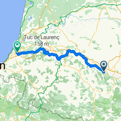
route des bosses PH Arbus-louvie-pedehourat-nay-rebenacq-lasseube
A cycling route starting in Arbus, Nouvelle-Aquitaine, France.
Overview
About this route
- -:--
- Duration
- 115 km
- Distance
- 977 m
- Ascent
- 983 m
- Descent
- ---
- Avg. speed
- ---
- Max. altitude

Route quality
Waytypes & surfaces along the route
Waytypes
Busy road
51.2 km
(45 %)
Road
43.8 km
(38 %)
Surfaces
Paved
61.4 km
(53 %)
Unpaved
1.1 km
(<1 %)
Asphalt
61.4 km
(53 %)
Gravel
1.1 km
(<1 %)
Undefined
52.5 km
(46 %)
Continue with Bikemap
Use, edit, or download this cycling route
You would like to ride route des bosses PH Arbus-louvie-pedehourat-nay-rebenacq-lasseube or customize it for your own trip? Here is what you can do with this Bikemap route:
Free features
- Save this route as favorite or in collections
- Copy & plan your own version of this route
- Split it into stages to create a multi-day tour
- Sync your route with Garmin or Wahoo
Premium features
Free trial for 3 days, or one-time payment. More about Bikemap Premium.
- Navigate this route on iOS & Android
- Export a GPX / KML file of this route
- Create your custom printout (try it for free)
- Download this route for offline navigation
Discover more Premium features.
Get Bikemap PremiumFrom our community
Other popular routes starting in Arbus
 De D804, Arbus à D2, Arbus
- Distance
- 1.5 km
- Ascent
- 38 m
- Descent
- 39 m
- Location
- Arbus, Nouvelle-Aquitaine, France
 Itinéraire à partir de Rue des Écoles
- Distance
- 119.7 km
- Ascent
- 886 m
- Descent
- 1,021 m
- Location
- Arbus, Nouvelle-Aquitaine, France
 route des bosses PH Arbus-louvie-pedehourat-nay-rebenacq-lasseube
- Distance
- 115 km
- Ascent
- 977 m
- Descent
- 983 m
- Location
- Arbus, Nouvelle-Aquitaine, France
 arbus- sainte andre de seignanx
- Distance
- 98.7 km
- Ascent
- 126 m
- Descent
- 211 m
- Location
- Arbus, Nouvelle-Aquitaine, France
 Route de crête
- Distance
- 33.7 km
- Ascent
- 384 m
- Descent
- 383 m
- Location
- Arbus, Nouvelle-Aquitaine, France
 dfgdfg
- Distance
- 1.8 km
- Ascent
- 0 m
- Descent
- 0 m
- Location
- Arbus, Nouvelle-Aquitaine, France
 arbus- sainte andre de seignanx
- Distance
- 96.1 km
- Ascent
- 195 m
- Descent
- 326 m
- Location
- Arbus, Nouvelle-Aquitaine, France
Open it in the app