

Geislingen-Eselhöfe-Oppingen
A cycling route starting in Geislingen an der Steige, Baden-Wurttemberg, Germany.
Overview
About this route
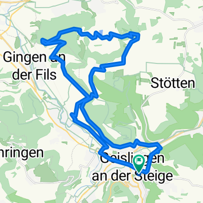
Die Rennrad-Runde startet und endet beim TVA in Geislingen. Zuerst gehts es das Täle raus bis Mühlhausen. Von dort geht es bergauf zu den Eselhöfen und dort auf den höchsten Punkt. Zurück geht über die Alb nach Drackenstein vorbei am Flugplatz Berneck nach Aufhausen. Jetzt geht es noch über ein Schleife nach Nellingen und Oppingen bis Türkheim. Von dort dann wieder bergab nach Geislingen zum Ausgangspunkt.
- -:--
- Duration
- 56 km
- Distance
- 699 m
- Ascent
- 680 m
- Descent
- ---
- Avg. speed
- 805 m
- Max. altitude

Route quality
Waytypes & surfaces along the route
Waytypes
Quiet road
27.1 km
(48 %)
Road
7.3 km
(13 %)
Surfaces
Paved
34.7 km
(62 %)
Unpaved
0.6 km
(<1 %)
Asphalt
31.5 km
(56 %)
Paved (undefined)
3.1 km
(6 %)
Continue with Bikemap
Use, edit, or download this cycling route
You would like to ride Geislingen-Eselhöfe-Oppingen or customize it for your own trip? Here is what you can do with this Bikemap route:
Free features
- Save this route as favorite or in collections
- Copy & plan your own version of this route
- Sync your route with Garmin or Wahoo
Premium features
Free trial for 3 days, or one-time payment. More about Bikemap Premium.
- Navigate this route on iOS & Android
- Export a GPX / KML file of this route
- Create your custom printout (try it for free)
- Download this route for offline navigation
Discover more Premium features.
Get Bikemap PremiumFrom our community
Other popular routes starting in Geislingen an der Steige
 Marrenwald-Kuchalb
- Distance
- 26 km
- Ascent
- 720 m
- Descent
- 693 m
- Location
- Geislingen an der Steige, Baden-Wurttemberg, Germany
 Geislingen-Kuchalb-Weißenstein-Runde
- Distance
- 42.1 km
- Ascent
- 1,437 m
- Descent
- 1,411 m
- Location
- Geislingen an der Steige, Baden-Wurttemberg, Germany
 geislingen
- Distance
- 22.9 km
- Ascent
- 1,268 m
- Descent
- 1,267 m
- Location
- Geislingen an der Steige, Baden-Wurttemberg, Germany
 Geislingen - Fuckseck
- Distance
- 37.5 km
- Ascent
- 628 m
- Descent
- 609 m
- Location
- Geislingen an der Steige, Baden-Wurttemberg, Germany
 Löwenpfad Weitblickrunde Geislingen Steige
- Distance
- 13.2 km
- Ascent
- 352 m
- Descent
- 352 m
- Location
- Geislingen an der Steige, Baden-Wurttemberg, Germany
 Marrenwald-Oberweckerstell
- Distance
- 26.9 km
- Ascent
- 547 m
- Descent
- 545 m
- Location
- Geislingen an der Steige, Baden-Wurttemberg, Germany
 Geislingen-Eselhöfe-Oppingen
- Distance
- 56 km
- Ascent
- 699 m
- Descent
- 680 m
- Location
- Geislingen an der Steige, Baden-Wurttemberg, Germany
 Geislingen - Ulm
- Distance
- 107.8 km
- Ascent
- 1,050 m
- Descent
- 820 m
- Location
- Geislingen an der Steige, Baden-Wurttemberg, Germany
Open it in the app