

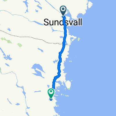
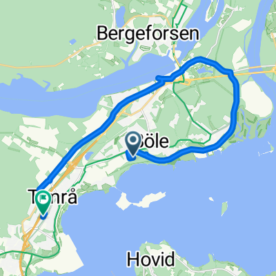
Transportväg till Sättna Flygfält
A cycling route starting in Timrå, Västernorrland County, Sweden.
Overview
About this route
Drive from V86 towards Ånäsparken and Sättna Kyrka. Head towards Norrbäcken up to the airfield. Park on the straight stretch before the gates and the entrance to the field.
- -:--
- Duration
- 9.6 km
- Distance
- 258 m
- Ascent
- 24 m
- Descent
- ---
- Avg. speed
- ---
- Max. altitude

Route quality
Waytypes & surfaces along the route
Waytypes
Road
5.3 km
(55 %)
Track
2.1 km
(22 %)
Surfaces
Paved
1.4 km
(15 %)
Unpaved
8.1 km
(85 %)
Loose gravel
4.8 km
(50 %)
Unpaved (undefined)
3.4 km
(35 %)
Asphalt
1.4 km
(15 %)
Continue with Bikemap
Use, edit, or download this cycling route
You would like to ride Transportväg till Sättna Flygfält or customize it for your own trip? Here is what you can do with this Bikemap route:
Free features
- Save this route as favorite or in collections
- Copy & plan your own version of this route
- Sync your route with Garmin or Wahoo
Premium features
Free trial for 3 days, or one-time payment. More about Bikemap Premium.
- Navigate this route on iOS & Android
- Export a GPX / KML file of this route
- Create your custom printout (try it for free)
- Download this route for offline navigation
Discover more Premium features.
Get Bikemap PremiumFrom our community
Other popular routes starting in Timrå
 Timrå - Iggesund
- Distance
- 137.7 km
- Ascent
- 1,089 m
- Descent
- 1,081 m
- Location
- Timrå, Västernorrland County, Sweden
 ART Timrå GP Korta banan
- Distance
- 1.6 km
- Ascent
- 13 m
- Descent
- 13 m
- Location
- Timrå, Västernorrland County, Sweden
 ARTUR ETAPP 8
- Distance
- 9.1 km
- Ascent
- 63 m
- Descent
- 72 m
- Location
- Timrå, Västernorrland County, Sweden
 Transportväg till Sättna Flygfält
- Distance
- 9.6 km
- Ascent
- 258 m
- Descent
- 24 m
- Location
- Timrå, Västernorrland County, Sweden
 ART TGP (korta banan)
- Distance
- 1.6 km
- Ascent
- 8 m
- Descent
- 8 m
- Location
- Timrå, Västernorrland County, Sweden
 Solrosvägen, Sörberge to Skogsvägen, Timrå
- Distance
- 12.1 km
- Ascent
- 90 m
- Descent
- 70 m
- Location
- Timrå, Västernorrland County, Sweden
 TIMRÅ GP
- Distance
- 1.6 km
- Ascent
- 8 m
- Descent
- 8 m
- Location
- Timrå, Västernorrland County, Sweden
 Day 17
- Distance
- 83.8 km
- Ascent
- 488 m
- Descent
- 502 m
- Location
- Timrå, Västernorrland County, Sweden
Open it in the app