

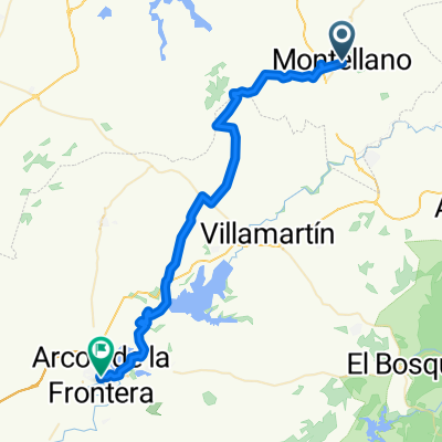
Montellano 13-03-2011
A cycling route starting in Montellano, Andalusia, Spain.
Overview
About this route
Ruta espectacular, con rapidas bajadas y tecnicas.
EXTREM
- -:--
- Duration
- 21.4 km
- Distance
- 762 m
- Ascent
- 762 m
- Descent
- ---
- Avg. speed
- ---
- Max. altitude

Continue with Bikemap
Use, edit, or download this cycling route
You would like to ride Montellano 13-03-2011 or customize it for your own trip? Here is what you can do with this Bikemap route:
Free features
- Save this route as favorite or in collections
- Copy & plan your own version of this route
- Sync your route with Garmin or Wahoo
Premium features
Free trial for 3 days, or one-time payment. More about Bikemap Premium.
- Navigate this route on iOS & Android
- Export a GPX / KML file of this route
- Create your custom printout (try it for free)
- Download this route for offline navigation
Discover more Premium features.
Get Bikemap PremiumFrom our community
Other popular routes starting in Montellano
 Montellano-Las Palomas
- Distance
- 142.3 km
- Ascent
- 2,263 m
- Descent
- 2,281 m
- Location
- Montellano, Andalusia, Spain
 Montellano Hispabtt
- Distance
- 50.3 km
- Ascent
- 995 m
- Descent
- 989 m
- Location
- Montellano, Andalusia, Spain
 Montellano 13-03-2011
- Distance
- 21.4 km
- Ascent
- 762 m
- Descent
- 762 m
- Location
- Montellano, Andalusia, Spain
 Montellano to Arcos
- Distance
- 50.5 km
- Ascent
- 377 m
- Descent
- 472 m
- Location
- Montellano, Andalusia, Spain
 3DAY3PtOfInterest
- Distance
- 61.4 km
- Ascent
- 504 m
- Descent
- 636 m
- Location
- Montellano, Andalusia, Spain
 Montellano y las 3 subidas 7-11-10 ZONA-ESTE BTT
- Distance
- 45.8 km
- Ascent
- 1,013 m
- Descent
- 1,013 m
- Location
- Montellano, Andalusia, Spain
 Montellano - Zahara d l Sierra
- Distance
- 37.3 km
- Ascent
- 760 m
- Descent
- 608 m
- Location
- Montellano, Andalusia, Spain
 Las Palomas
- Distance
- 115.7 km
- Ascent
- 1,736 m
- Descent
- 1,741 m
- Location
- Montellano, Andalusia, Spain
Open it in the app