

Greenhill slog 20 3 10
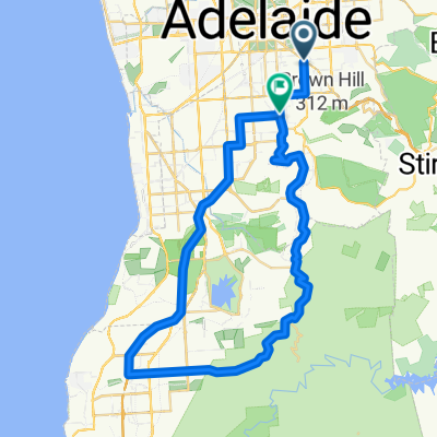
A cycling route starting in Fullarton, South Australia, Australia.
Overview
About this route
Why did I suggest Greenhill Rd today? It just keeps giving and giving and giving... down it at 70km/hr is much more fun than up it at 11km/hr...
- -:--
- Duration
- 47 km
- Distance
- 824 m
- Ascent
- 827 m
- Descent
- ---
- Avg. speed
- ---
- Max. altitude
Route quality
Waytypes & surfaces along the route
Waytypes
Quiet road
11.3 km
(24 %)
Road
4.7 km
(10 %)
Undefined
31 km
(66 %)
Surfaces
Paved
46.1 km
(98 %)
Unpaved
0.5 km
(1 %)
Asphalt
44.7 km
(95 %)
Paved (undefined)
1.4 km
(3 %)
Continue with Bikemap
Use, edit, or download this cycling route
You would like to ride Greenhill slog 20 3 10 or customize it for your own trip? Here is what you can do with this Bikemap route:
Free features
- Save this route as favorite or in collections
- Copy & plan your own version of this route
- Sync your route with Garmin or Wahoo
Premium features
Free trial for 3 days, or one-time payment. More about Bikemap Premium.
- Navigate this route on iOS & Android
- Export a GPX / KML file of this route
- Create your custom printout (try it for free)
- Download this route for offline navigation
Discover more Premium features.
Get Bikemap PremiumFrom our community
Other popular routes starting in Fullarton
 Greenhill slog 20 3 10
- Distance
- 47 km
- Ascent
- 824 m
- Descent
- 827 m
- Location
- Fullarton, South Australia, Australia
 Swedish Tart 3-Egg Omelette Ride
- Distance
- 78.2 km
- Ascent
- 194 m
- Descent
- 194 m
- Location
- Fullarton, South Australia, Australia
 TDU Saturday
- Distance
- 36.5 km
- Ascent
- 1,035 m
- Descent
- 1,033 m
- Location
- Fullarton, South Australia, Australia
 the Jesus loop
- Distance
- 113.9 km
- Ascent
- 903 m
- Descent
- 929 m
- Location
- Fullarton, South Australia, Australia
 Coromandel Valley and Sthern bikeway
- Distance
- 57 km
- Ascent
- 653 m
- Descent
- 644 m
- Location
- Fullarton, South Australia, Australia
 Clarendon - Scott Creek - Stirling
- Distance
- 68.5 km
- Ascent
- 976 m
- Descent
- 976 m
- Location
- Fullarton, South Australia, Australia
 Hills via Gorge, Lobethal, Woodside down Greenhill Road
- Distance
- 81.8 km
- Ascent
- 980 m
- Descent
- 668 m
- Location
- Fullarton, South Australia, Australia
 Myrtle Bank to Tanunda
- Distance
- 99.1 km
- Ascent
- 316 m
- Descent
- 169 m
- Location
- Fullarton, South Australia, Australia
Open it in the app