

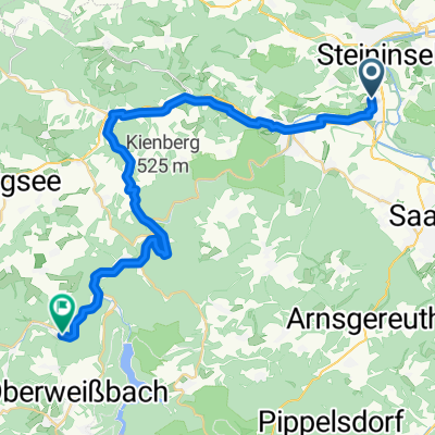
MTB Tour 5
A cycling route starting in Rudolstadt, Thuringia, Germany.
Overview
About this route
- -:--
- Duration
- 76.2 km
- Distance
- 1,181 m
- Ascent
- 1,149 m
- Descent
- ---
- Avg. speed
- 544 m
- Max. altitude
Route quality
Waytypes & surfaces along the route
Waytypes
Track
45.7 km
(60 %)
Quiet road
11.4 km
(15 %)
Surfaces
Paved
24.4 km
(32 %)
Unpaved
41.9 km
(55 %)
Gravel
28.2 km
(37 %)
Asphalt
21.3 km
(28 %)
Route highlights
Points of interest along the route

Point of interest after 1 km
Schloss Heidecksburg

Point of interest after 22.1 km
Schauenforst

Point of interest after 29.6 km
Luisenturm
Point of interest after 37.9 km
Schutzhütte und Aussichtspunkt Kretzberg

Point of interest after 52.4 km
Burgrunine Ehrenstein

Point of interest after 60.6 km
Baropturm

Point of interest after 61 km
Fröbelblick

Point of interest after 63.7 km
Modell Burg Greifenstein

Point of interest after 63.8 km
Burg Greifenstein

Point of interest after 63.8 km
Burg Greifenstein bei Nacht

Point of interest after 72.3 km
Schillershöhe
Continue with Bikemap
Use, edit, or download this cycling route
You would like to ride MTB Tour 5 or customize it for your own trip? Here is what you can do with this Bikemap route:
Free features
- Save this route as favorite or in collections
- Copy & plan your own version of this route
- Sync your route with Garmin or Wahoo
Premium features
Free trial for 3 days, or one-time payment. More about Bikemap Premium.
- Navigate this route on iOS & Android
- Export a GPX / KML file of this route
- Create your custom printout (try it for free)
- Download this route for offline navigation
Discover more Premium features.
Get Bikemap PremiumFrom our community
Other popular routes starting in Rudolstadt
 Rund um den Ehrenstein
- Distance
- 36.7 km
- Ascent
- 388 m
- Descent
- 388 m
- Location
- Rudolstadt, Thuringia, Germany
 MTB Tour 4
- Distance
- 52 km
- Ascent
- 720 m
- Descent
- 723 m
- Location
- Rudolstadt, Thuringia, Germany
 Auf dem Saale/Ilm und Klosterradweg
- Distance
- 53.5 km
- Ascent
- 462 m
- Descent
- 459 m
- Location
- Rudolstadt, Thuringia, Germany
 RU-Oberweissbach-Solsdorf II
- Distance
- 82.5 km
- Ascent
- 1,219 m
- Descent
- 1,219 m
- Location
- Rudolstadt, Thuringia, Germany
 Aufnahme vom 7. Juni 14:43
- Distance
- 51 km
- Ascent
- 554 m
- Descent
- 555 m
- Location
- Rudolstadt, Thuringia, Germany
 Uphill von Teichröda zum Grünen Stern
- Distance
- 21.3 km
- Ascent
- 478 m
- Descent
- 456 m
- Location
- Rudolstadt, Thuringia, Germany
 Fahrradtour RU-Rottenbach-Bergbahn
- Distance
- 29.3 km
- Ascent
- 380 m
- Descent
- 263 m
- Location
- Rudolstadt, Thuringia, Germany
 MTB Tour 5
- Distance
- 76.2 km
- Ascent
- 1,181 m
- Descent
- 1,149 m
- Location
- Rudolstadt, Thuringia, Germany
Open it in the app