
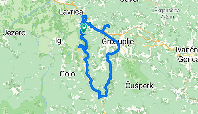
preko Turjaka na Magdalensko goro
A cycling route starting in Škofljica, Občina Škofljica, Slovenia.
Overview
About this route
- -:--
- Duration
- 48 km
- Distance
- 658 m
- Ascent
- 658 m
- Descent
- ---
- Avg. speed
- ---
- Max. altitude
Route quality
Waytypes & surfaces along the route
Waytypes
Quiet road
24.5 km
(51 %)
Road
10.1 km
(21 %)
Surfaces
Paved
29.3 km
(61 %)
Unpaved
1.9 km
(4 %)
Asphalt
24 km
(50 %)
Paved (undefined)
5.3 km
(11 %)
Route highlights
Points of interest along the route

Point of interest after 23.3 km
Županova jama

Point of interest after 23.8 km
Tabor Cerovo

Point of interest after 35.8 km
Magdalenska gora

Point of interest after 43.7 km
grad Lisičje
Continue with Bikemap
Use, edit, or download this cycling route
You would like to ride preko Turjaka na Magdalensko goro or customize it for your own trip? Here is what you can do with this Bikemap route:
Free features
- Save this route as favorite or in collections
- Copy & plan your own version of this route
- Sync your route with Garmin or Wahoo
Premium features
Free trial for 3 days, or one-time payment. More about Bikemap Premium.
- Navigate this route on iOS & Android
- Export a GPX / KML file of this route
- Create your custom printout (try it for free)
- Download this route for offline navigation
Discover more Premium features.
Get Bikemap PremiumFrom our community
Other popular routes starting in Škofljica
 Pot na Krim
- Distance
- 68.2 km
- Ascent
- 836 m
- Descent
- 836 m
- Location
- Škofljica, Občina Škofljica, Slovenia
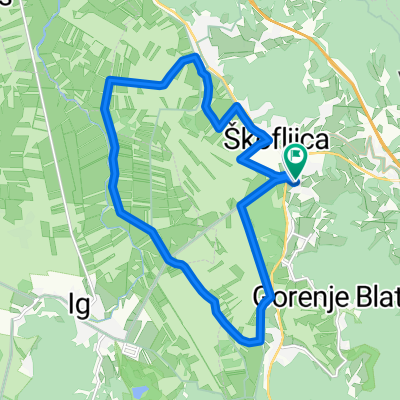
 Škofljica-Ig-Turjak-Grosuplje-Šk
- Distance
- 48.2 km
- Ascent
- 365 m
- Descent
- 360 m
- Location
- Škofljica, Občina Škofljica, Slovenia
 Družinska kolesarska pot po Škofljici
- Distance
- 15.8 km
- Ascent
- 52 m
- Descent
- 49 m
- Location
- Škofljica, Občina Škofljica, Slovenia
 Kurešček
- Distance
- 73.7 km
- Ascent
- 912 m
- Descent
- 912 m
- Location
- Škofljica, Občina Škofljica, Slovenia
 preko Turjaka na Magdalensko goro
- Distance
- 48 km
- Ascent
- 658 m
- Descent
- 658 m
- Location
- Škofljica, Občina Škofljica, Slovenia
 Zalog pri Škofljici, Škofljica to Ulica Slanik, Lovrečica
- Distance
- 166.1 km
- Ascent
- 1,311 m
- Descent
- 1,649 m
- Location
- Škofljica, Občina Škofljica, Slovenia
 Škofljica - Turjak - Škofljica
- Distance
- 55.8 km
- Ascent
- 1,221 m
- Descent
- 1,223 m
- Location
- Škofljica, Občina Škofljica, Slovenia
 Pot na Rašico
- Distance
- 39.5 km
- Ascent
- 446 m
- Descent
- 446 m
- Location
- Škofljica, Občina Škofljica, Slovenia
Open it in the app