

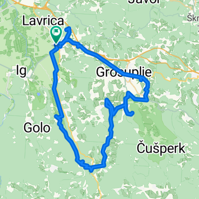
Pot na Rašico
A cycling route starting in Škofljica, Občina Škofljica, Slovenia.
Overview
About this route
- -:--
- Duration
- 39.5 km
- Distance
- 446 m
- Ascent
- 446 m
- Descent
- ---
- Avg. speed
- ---
- Max. altitude
Route quality
Waytypes & surfaces along the route
Waytypes
Quiet road
17 km
(43 %)
Track
5.9 km
(15 %)
Surfaces
Paved
30.8 km
(78 %)
Unpaved
5.1 km
(13 %)
Asphalt
29.2 km
(74 %)
Gravel
4.3 km
(11 %)
Route highlights
Points of interest along the route

Point of interest after 5.8 km
Ljubljansko barje

Point of interest after 11.1 km
Želimlje je zanimiva vasica, ki ima škofijsko gimnazijo. Na griču pri ogromni lipi pa stoji graščina Namršelj.

Point of interest after 15.2 km
obnovljena domačija, ki ima po fasadi izobešena slikarska dela

Point of interest after 18.6 km
grad Turjak

Point of interest after 20.4 km
gozdna učna pot Turjak - Rašica

Point of interest after 24.3 km
Trubarjeva domačija

Point of interest after 27.7 km
Turjak - Spomenik žrtvam NOB v Smrečju
Continue with Bikemap
Use, edit, or download this cycling route
You would like to ride Pot na Rašico or customize it for your own trip? Here is what you can do with this Bikemap route:
Free features
- Save this route as favorite or in collections
- Copy & plan your own version of this route
- Sync your route with Garmin or Wahoo
Premium features
Free trial for 3 days, or one-time payment. More about Bikemap Premium.
- Navigate this route on iOS & Android
- Export a GPX / KML file of this route
- Create your custom printout (try it for free)
- Download this route for offline navigation
Discover more Premium features.
Get Bikemap PremiumFrom our community
Other popular routes starting in Škofljica
 Pot na Krim
- Distance
- 68.2 km
- Ascent
- 836 m
- Descent
- 836 m
- Location
- Škofljica, Občina Škofljica, Slovenia
 pot gradov_Grosuplje
- Distance
- 52.5 km
- Ascent
- 511 m
- Descent
- 511 m
- Location
- Škofljica, Občina Škofljica, Slovenia
 Pance Turjak Golo
- Distance
- 75.8 km
- Ascent
- 1,064 m
- Descent
- 1,059 m
- Location
- Škofljica, Občina Škofljica, Slovenia
 Škofljica-Ig-Turjak-Grosuplje-Šk
- Distance
- 48.2 km
- Ascent
- 365 m
- Descent
- 360 m
- Location
- Škofljica, Občina Škofljica, Slovenia
 Škofljica-Podpeč-Vrhnika-Škofljica
- Distance
- 66.5 km
- Ascent
- 98 m
- Descent
- 157 m
- Location
- Škofljica, Občina Škofljica, Slovenia
 Šk-turjak-grosuplje-šk
- Distance
- 40.3 km
- Ascent
- 340 m
- Descent
- 397 m
- Location
- Škofljica, Občina Škofljica, Slovenia
 Lj barje
- Distance
- 41.2 km
- Ascent
- 44 m
- Descent
- 49 m
- Location
- Škofljica, Občina Škofljica, Slovenia
 Južnomočvirska
- Distance
- 117.3 km
- Ascent
- 1,105 m
- Descent
- 1,101 m
- Location
- Škofljica, Občina Škofljica, Slovenia
Open it in the app