Von Gengenbach über Kornebene nach Steinenbach und zurück
- 42.3 km
- 1,249 m
- 1,257 m
- Gengenbach, Hesse, Germany
A cycling route starting in Gengenbach, Hesse, Germany.
Overview
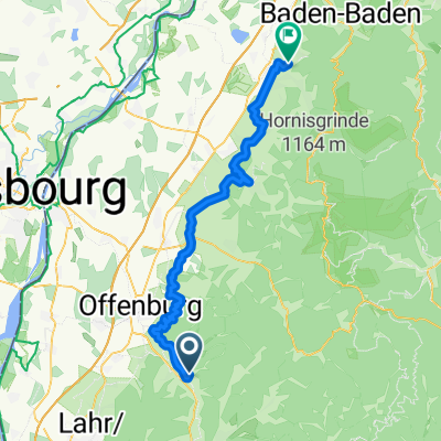
Badischer Wine Cycle Route
The fourth stage of the Badischer Wine Cycle Route covers around 56 km through the wine region of Ortenau.
From Gengenbach, the stage runs along the edge of the Black Forest and ends after 56 km in Bühl.
The vineyards between the Rhine plain and the heights of the Black Forest are characterized by steep slopes. Castles like Ortenberg (just before Offenburg) or Staufenberg (Durbach), fortresses, and monasteries (Erlenbad, near Sasbach) bear witness to a centuries-old tradition and wine culture.
In addition to wine, the seasonal variety of fruit and vegetables plays a significant role, which is especially noticeable around Oberkirch. This is also reflected in the distillery industry: there are over 7,000 small distillers in Ortenau.
created this 4 years ago
Route quality
Track
15.3 km
(26 %)
Road
14.7 km
(25 %)
Paved
51.7 km
(88 %)
Unpaved
4.1 km
(7 %)
Asphalt
49.3 km
(84 %)
Paved (undefined)
2.3 km
(4 %)
Continue with Bikemap
You would like to ride 3. Etappe von Gengenbach nach Bühl or customize it for your own trip? Here is what you can do with this Bikemap route:
Free trial for 3 days, or one-time payment. More about Bikemap Premium.
Discover more Premium features.
Get Bikemap PremiumFrom our community
Open it in the app