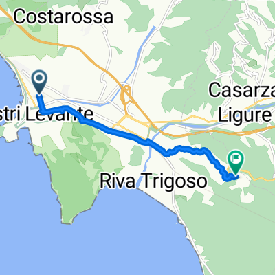
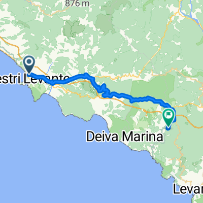
Sestri Levante
- 80 km
- 1,867 m
- 1,867 m
- Sestri Levante, Liguria, Italy
A cycling route starting in Sestri Levante, Liguria, Italy.
Overview
Percorso mtb su anello in senso orario
Si raggiunge il campeggio S. Anna e si sale per la strada dei ponti fino a raggiungere le Rocche di S. Anna. Si prosegue sul sentiero fino a Cavi Borgo (attenzione all'ultimo tratto per scendere sulla strada asfaltata). Raggiungiamo Santa Giulia con l'ultimo breve tratto sul sentiero delle "pietre parlanti" (anche qui attenzione!!! E' un sentiero stretto, in alcuni tratti esposto sulla sinistra e senza protezioni). Si ritorna indietro, poi si sale per un paio di chilometri. Si scende a Sorlana, poi alcuni sali e scendi per arrivare a Barassi. Dopo circa 2 km giriamo a sx su una stradina direzione Cerreto. Ora ci attendono un paio di chilometri di sterrato per raggiungere Costarossa, con alcuni single track e dei cancelli (che vanno richiusi). A Costarossa ritroviamo l'asfalto e scendiamo a San Bernardo, poi per alcune stradine raggiungiamo velocemente a Sestri.
created this 4 years ago
Route quality
Quiet road
8.4 km
(38 %)
Road
7.6 km
(34 %)
Paved
4.2 km
(19 %)
Unpaved
2.9 km
(13 %)
Asphalt
4 km
(18 %)
Ground
2.7 km
(12 %)
Continue with Bikemap
You would like to ride Sestri Levante-sentiero Rocche S.Anna-Santa Giulia-Costarossa-Sestri L. or customize it for your own trip? Here is what you can do with this Bikemap route:
Free trial for 3 days, or one-time payment. More about Bikemap Premium.
Discover more Premium features.
Get Bikemap PremiumFrom our community
Open it in the app