
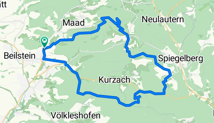
Wald und Wiesenweg Test
A cycling route starting in Beilstein, Baden-Württemberg, Germany.
Overview
About this route
Test noch nicht gefahen
- -:--
- Duration
- 25.7 km
- Distance
- 538 m
- Ascent
- 538 m
- Descent
- ---
- Avg. speed
- ---
- Max. altitude
Route quality
Waytypes & surfaces along the route
Waytypes
Track
19.5 km
(76 %)
Road
2 km
(8 %)
Surfaces
Paved
10.5 km
(41 %)
Unpaved
14.1 km
(55 %)
Gravel
13 km
(50 %)
Asphalt
7.9 km
(31 %)
Route highlights
Points of interest along the route
Point of interest after 8.6 km
See ?
Continue with Bikemap
Use, edit, or download this cycling route
You would like to ride Wald und Wiesenweg Test or customize it for your own trip? Here is what you can do with this Bikemap route:
Free features
- Save this route as favorite or in collections
- Copy & plan your own version of this route
- Sync your route with Garmin or Wahoo
Premium features
Free trial for 3 days, or one-time payment. More about Bikemap Premium.
- Navigate this route on iOS & Android
- Export a GPX / KML file of this route
- Create your custom printout (try it for free)
- Download this route for offline navigation
Discover more Premium features.
Get Bikemap PremiumFrom our community
Other popular routes starting in Beilstein
 Wald und Wiesenweg Test
- Distance
- 25.7 km
- Ascent
- 538 m
- Descent
- 538 m
- Location
- Beilstein, Baden-Württemberg, Germany
 WaldundWiesenweg
- Distance
- 26.3 km
- Ascent
- 564 m
- Descent
- 564 m
- Location
- Beilstein, Baden-Württemberg, Germany
 Stromberg Heuchelberg
- Distance
- 85 km
- Ascent
- 583 m
- Descent
- 583 m
- Location
- Beilstein, Baden-Württemberg, Germany
 Amalienhof Beilstein
- Distance
- 9.3 km
- Ascent
- 308 m
- Descent
- 310 m
- Location
- Beilstein, Baden-Württemberg, Germany
 trailsurfers Beilstein
- Distance
- 26.5 km
- Ascent
- 543 m
- Descent
- 540 m
- Location
- Beilstein, Baden-Württemberg, Germany
 Prevorst Bergzeitfahrstrecke
- Distance
- 3.3 km
- Ascent
- 215 m
- Descent
- 29 m
- Location
- Beilstein, Baden-Württemberg, Germany
 SB4 Mountainbikerunde - Radweg im Schozachtal
- Distance
- 35.9 km
- Ascent
- 638 m
- Descent
- 637 m
- Location
- Beilstein, Baden-Württemberg, Germany
 Kochertal (Bad Friedrichshall - Gaildorf)
- Distance
- 177.2 km
- Ascent
- 551 m
- Descent
- 551 m
- Location
- Beilstein, Baden-Württemberg, Germany
Open it in the app