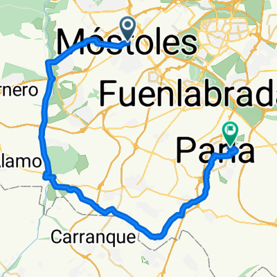
![[BIKENEX Madrid] Alcorcon - Boadilla - Las Lomas - El Bosque - Mostoles](https://media.bikemap.net/routes/862913/staticmaps/in_9ef94e5f-6994-4a62-8f8b-c2d716192c71_694x400_bikemap-2021-3D-static.png)

Ida y vuelta al curro 27/06/2011
- 16.3 km
- 88 m
- 94 m
- Móstoles, Madrid, Spain
Magnificent route.
NOTE: the current route is somewhat modified because there have been works and some paths have been cut off. Therefore, the track for a GPS would not be entirely correct.
Starting from Tres Aguas, in ALCORCÓN (easy access, plenty of room to park your car), you reach Boadilla passing in front of and behind the Ciudad del Santander. You cross the tracks of the MetroLigero.
Passing in front of the Palace of Boadilla, crossing and surrounding the Boadilla forest, you reach some significant descents just behind Las Lomas, with a couple of interesting drops.
Leaving Boadilla behind, you enter no man's land and will encounter a descent, which if you are a beginner, it's worth thinking twice about.
Continuing, you take the road (usually there is not much traffic) and drop down to the satellite tracking station on one side, and on the other a watchtower watching over the 2 valleys.
You enter the Guadarrama basin, a magnificent place to ride your bike at any time of the year.
Arriving at El Bosque, you cross the city, passing by the golf course and return to MOSTOLES, crossing the Sacedón.
Free trial for 3 days, or one-time payment. More about Bikemap Premium.
Discover more Premium features.
Get Bikemap PremiumOpen it in the app
![[BIKENEX Madrid] Alcorcon - Boadilla - Las Lomas - El Bosque - Mostoles](https://media.bikemap.net/routes/862913/staticmaps/in_9ef94e5f-6994-4a62-8f8b-c2d716192c71_400x400_bikemap-2021-3D-static.png)