

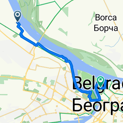
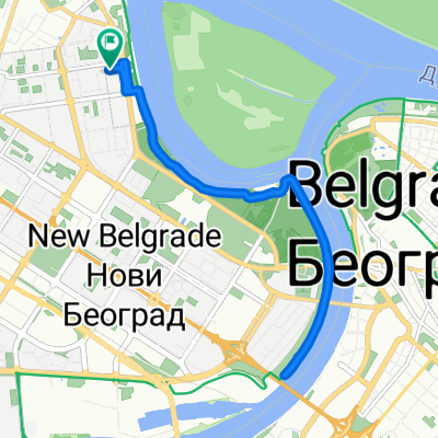
Kej oslobodjenja, Belgrade to Džona Kenedija 5/A, Belgrade
A cycling route starting in Zemun, Central Serbia, Serbia.
Overview
About this route
- 1 h 5 min
- Duration
- 19.6 km
- Distance
- 0 m
- Ascent
- 19 m
- Descent
- 18.1 km/h
- Avg. speed
- ---
- Max. altitude
Route quality
Waytypes & surfaces along the route
Waytypes
Cycleway
15.7 km
(80 %)
Pedestrian area
1.8 km
(9 %)
Surfaces
Paved
14.7 km
(75 %)
Asphalt
14.5 km
(74 %)
Concrete
0.2 km
(1 %)
Undefined
4.9 km
(25 %)
Continue with Bikemap
Use, edit, or download this cycling route
You would like to ride Kej oslobodjenja, Belgrade to Džona Kenedija 5/A, Belgrade or customize it for your own trip? Here is what you can do with this Bikemap route:
Free features
- Save this route as favorite or in collections
- Copy & plan your own version of this route
- Sync your route with Garmin or Wahoo
Premium features
Free trial for 3 days, or one-time payment. More about Bikemap Premium.
- Navigate this route on iOS & Android
- Export a GPX / KML file of this route
- Create your custom printout (try it for free)
- Download this route for offline navigation
Discover more Premium features.
Get Bikemap PremiumFrom our community
Other popular routes starting in Zemun
 Hala Sportova - Ostružnički most
- Distance
- 27.4 km
- Ascent
- 41 m
- Descent
- 38 m
- Location
- Zemun, Central Serbia, Serbia
 Studentska 25, Beograd to Studentska 10, Beograd
- Distance
- 86.4 km
- Ascent
- 832 m
- Descent
- 1,448 m
- Location
- Zemun, Central Serbia, Serbia
 Festung Belgrad
- Distance
- 16.9 km
- Ascent
- 100 m
- Descent
- 75 m
- Location
- Zemun, Central Serbia, Serbia
 Nedeljno popodne 09.06.2019.
- Distance
- 40.7 km
- Ascent
- 42 m
- Descent
- 52 m
- Location
- Zemun, Central Serbia, Serbia
 Klare Cetkin 7, Belgrade to Klare Cetkin 7, Belgrade
- Distance
- 10.7 km
- Ascent
- 35 m
- Descent
- 26 m
- Location
- Zemun, Central Serbia, Serbia
 Otprilike ruta - Ako/kad otvore granice
- Distance
- 542 km
- Ascent
- 1,062 m
- Descent
- 1,063 m
- Location
- Zemun, Central Serbia, Serbia
 vuk i 3 praseta
- Distance
- 38.1 km
- Ascent
- 12 m
- Descent
- 14 m
- Location
- Zemun, Central Serbia, Serbia
 Земун, Белград до Земун, Белград
- Distance
- 4.7 km
- Ascent
- 31 m
- Descent
- 30 m
- Location
- Zemun, Central Serbia, Serbia
Open it in the app