Junkerstraße 9, Büsingen am Hochrhein nach Höllturm-Passage 2, Radolfzell am Bodensee
A cycling route starting in Diessenhofen, Thurgau, Switzerland.
Overview
About this route
- 2 h 26 min
- Duration
- 39.3 km
- Distance
- 280 m
- Ascent
- 269 m
- Descent
- 16.2 km/h
- Avg. speed
- ---
- Avg. speed
Route quality
Waytypes & surfaces along the route
Waytypes
Quiet road
14.1 km
(36 %)
Path
11.3 km
(29 %)
Surfaces
Paved
31.2 km
(80 %)
Unpaved
7.4 km
(19 %)
Asphalt
31.2 km
(80 %)
Gravel
6.9 km
(18 %)
Continue with Bikemap
Use, edit, or download this cycling route
You would like to ride Junkerstraße 9, Büsingen am Hochrhein nach Höllturm-Passage 2, Radolfzell am Bodensee or customize it for your own trip? Here is what you can do with this Bikemap route:
Free features
- Save this route as favorite or in collections
- Copy & plan your own version of this route
- Sync your route with Garmin or Wahoo
Premium features
Free trial for 3 days, or one-time payment. More about Bikemap Premium.
- Navigate this route on iOS & Android
- Export a GPX / KML file of this route
- Create your custom printout (try it for free)
- Download this route for offline navigation
Discover more Premium features.
Get Bikemap PremiumFrom our community
Other popular routes starting in Diessenhofen
- Geissenbach - Stein am Rhein
- Distance
- 27.2 km
- Ascent
- 197 m
- Descent
- 188 m
- Location
- Diessenhofen, Thurgau, Switzerland
- Die einfache Runde
- Distance
- 47.4 km
- Ascent
- 214 m
- Descent
- 210 m
- Location
- Diessenhofen, Thurgau, Switzerland
- AT-Biketour 2014
- Distance
- 34 km
- Ascent
- 318 m
- Descent
- 318 m
- Location
- Diessenhofen, Thurgau, Switzerland
- Blickweg
- Distance
- 20.1 km
- Ascent
- 338 m
- Descent
- 337 m
- Location
- Diessenhofen, Thurgau, Switzerland
- Ramsenerblickweg
- Distance
- 16.9 km
- Ascent
- 325 m
- Descent
- 325 m
- Location
- Diessenhofen, Thurgau, Switzerland
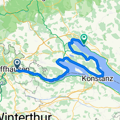
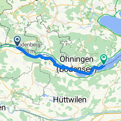
- Diessenhohen- Stein am Rhein
- Distance
- 20 km
- Ascent
- 214 m
- Descent
- 214 m
- Location
- Diessenhofen, Thurgau, Switzerland
- Rundtour über Rodenberg -Schienerberg - Hohenklingen
- Distance
- 45.8 km
- Ascent
- 1,010 m
- Descent
- 1,014 m
- Location
- Diessenhofen, Thurgau, Switzerland
- Diessenhofen - Schlattingen
- Distance
- 17.1 km
- Ascent
- 285 m
- Descent
- 282 m
- Location
- Diessenhofen, Thurgau, Switzerland
Open it in the app