

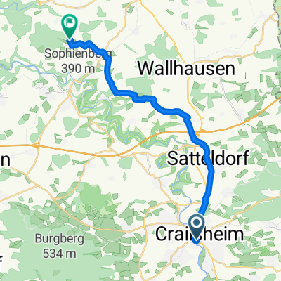
Onolzheim-Westliche Dörfer-Onolzheim
A cycling route starting in Crailsheim, Baden-Wurttemberg, Germany.
Overview
About this route
Onolzheim - Tiefenbach - Kirchberg - Lendsiedel - Dörrmenz - Ruppertshofen - Hörlebach - Hasfelden - Wolpertshausen - Reinsberg - Unterscheffach - Oberscheffach - Großaltdorf - Steinehaig - Spaichbühl - Brunzenberg - Gründelhardt - Hellmannshofen - Honhardt - Sandhof - Eckarrot - Randenweiler - Stimpfach - Jagstheim - Onolzheim
- -:--
- Duration
- 64.4 km
- Distance
- 474 m
- Ascent
- 474 m
- Descent
- ---
- Avg. speed
- ---
- Max. altitude

Route quality
Waytypes & surfaces along the route
Waytypes
Road
35.4 km
(55 %)
Quiet road
5.8 km
(9 %)
Surfaces
Paved
23.2 km
(36 %)
Asphalt
21.9 km
(34 %)
Paved (undefined)
1.3 km
(2 %)
Undefined
41.2 km
(64 %)
Continue with Bikemap
Use, edit, or download this cycling route
You would like to ride Onolzheim-Westliche Dörfer-Onolzheim or customize it for your own trip? Here is what you can do with this Bikemap route:
Free features
- Save this route as favorite or in collections
- Copy & plan your own version of this route
- Sync your route with Garmin or Wahoo
Premium features
Free trial for 3 days, or one-time payment. More about Bikemap Premium.
- Navigate this route on iOS & Android
- Export a GPX / KML file of this route
- Create your custom printout (try it for free)
- Download this route for offline navigation
Discover more Premium features.
Get Bikemap PremiumFrom our community
Other popular routes starting in Crailsheim
 1997 Jagst ab Crailsheim
- Distance
- 123.6 km
- Ascent
- 1,497 m
- Descent
- 1,719 m
- Location
- Crailsheim, Baden-Wurttemberg, Germany
 Onolzheim-Westliche Dörfer-Onolzheim
- Distance
- 64.4 km
- Ascent
- 474 m
- Descent
- 474 m
- Location
- Crailsheim, Baden-Wurttemberg, Germany
 Onolzheim-Brettheim-Kirchberg-Ilshofen-Onolzheim
- Distance
- 62 km
- Ascent
- 408 m
- Descent
- 396 m
- Location
- Crailsheim, Baden-Wurttemberg, Germany
 14.Crails.-Ellw.-Aalen-Ulm
- Distance
- 286.2 km
- Ascent
- 3,194 m
- Descent
- 3,281 m
- Location
- Crailsheim, Baden-Wurttemberg, Germany
 Crailsheim - Ilshofen
- Distance
- 16.3 km
- Ascent
- 195 m
- Descent
- 188 m
- Location
- Crailsheim, Baden-Wurttemberg, Germany
 Radrunde durch Crailsheim
- Distance
- 18 km
- Ascent
- 66 m
- Descent
- 63 m
- Location
- Crailsheim, Baden-Wurttemberg, Germany
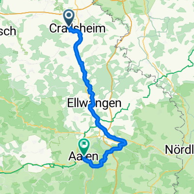 Crailsheim - Aalen 64km
- Distance
- 63.5 km
- Ascent
- 648 m
- Descent
- 636 m
- Location
- Crailsheim, Baden-Wurttemberg, Germany
 Kocher-Jagst-Radweg
- Distance
- 65.8 km
- Ascent
- 618 m
- Descent
- 789 m
- Location
- Crailsheim, Baden-Wurttemberg, Germany
Open it in the app