

Aedermannsdorf-Scheltentour
A cycling route starting in Matzendorf, Canton of Solothurn, Switzerland.
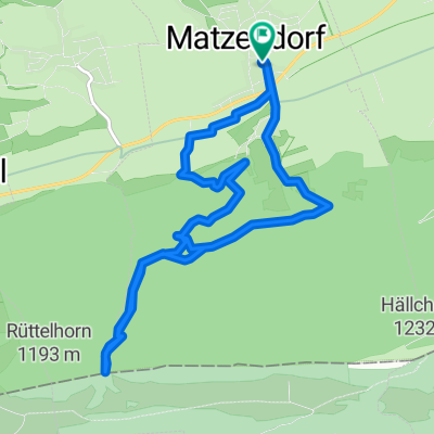
Overview
About this route
Start iun Aedermannsdorf, Laupersdorf-Höngen-Brunnersberg, Brocheten-Guldenthal-Schelten-Mervelier-Vermes-Seehof-Cremines-Welschenrohr-Aedermannsdorf (Schöne Juratour)
- -:--
- Duration
- 55.7 km
- Distance
- 1,760 m
- Ascent
- 1,699 m
- Descent
- ---
- Avg. speed
- 1,113 m
- Avg. speed
Route quality
Waytypes & surfaces along the route
Waytypes
Quiet road
20.1 km
(36 %)
Road
18 km
(32 %)
Surfaces
Paved
25.9 km
(46 %)
Unpaved
1 km
(2 %)
Asphalt
24.1 km
(43 %)
Paved (undefined)
1.8 km
(3 %)
Continue with Bikemap
Use, edit, or download this cycling route
You would like to ride Aedermannsdorf-Scheltentour or customize it for your own trip? Here is what you can do with this Bikemap route:
Free features
- Save this route as favorite or in collections
- Copy & plan your own version of this route
- Sync your route with Garmin or Wahoo
Premium features
Free trial for 3 days, or one-time payment. More about Bikemap Premium.
- Navigate this route on iOS & Android
- Export a GPX / KML file of this route
- Create your custom printout (try it for free)
- Download this route for offline navigation
Discover more Premium features.
Get Bikemap PremiumFrom our community
Other popular routes starting in Matzendorf
 Aed'dorf-Malsenberg-vord.Brandberg
- Distance
- 32 km
- Ascent
- 1,160 m
- Descent
- 1,160 m
- Location
- Matzendorf, Canton of Solothurn, Switzerland
 Gäupark
- Distance
- 41.7 km
- Ascent
- 439 m
- Descent
- 439 m
- Location
- Matzendorf, Canton of Solothurn, Switzerland
 Lengthy Donnerstag Track In Aedermann
- Distance
- 12.2 km
- Ascent
- 40 m
- Descent
- 46 m
- Location
- Matzendorf, Canton of Solothurn, Switzerland
 Aedermannsdorf-Laupersdorf-Brunnersberg-
- Distance
- 33.1 km
- Ascent
- 929 m
- Descent
- 950 m
- Location
- Matzendorf, Canton of Solothurn, Switzerland
 Rundkurs 1
- Distance
- 22.9 km
- Ascent
- 672 m
- Descent
- 672 m
- Location
- Matzendorf, Canton of Solothurn, Switzerland
 Die 3 Seen - dag 3
- Distance
- 86.5 km
- Ascent
- 923 m
- Descent
- 963 m
- Location
- Matzendorf, Canton of Solothurn, Switzerland
 Herbetswil-Weissenstein
- Distance
- 16.8 km
- Ascent
- 787 m
- Descent
- 57 m
- Location
- Matzendorf, Canton of Solothurn, Switzerland
 Dorfstrasse, Matzendorf nach Dorfstrasse, Matzendorf
- Distance
- 10.2 km
- Ascent
- 570 m
- Descent
- 570 m
- Location
- Matzendorf, Canton of Solothurn, Switzerland
Open it in the app