

l'Ardèche fleurie
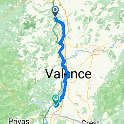
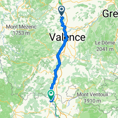
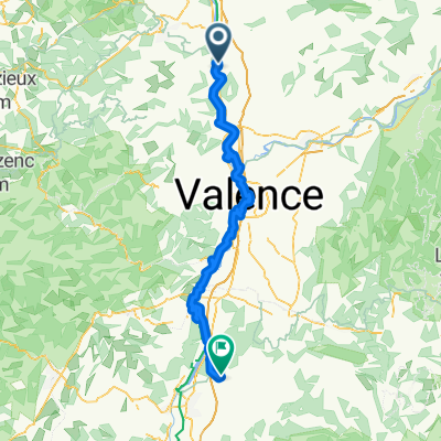
A cycling route starting in Saint-Vallier, Auvergne-Rhône-Alpes, France.
Overview
About this route
Route passing through 'the col', the col de juvenet, the col de Fontay, the col du Gibet, the col du Marchand, the col du Faux, the col du Buisson, the Tracol, the col de Fontreyde, the col Perrier, the col de la combe de Beaune, and the col de Nesson before returning to Tain l'Hermitage.
Tain l'Hermitage to Lyon Part Dieu: 1 hour and 6.90 euros.
- -:--
- Duration
- 113 km
- Distance
- 1,511 m
- Ascent
- 1,529 m
- Descent
- ---
- Avg. speed
- ---
- Max. altitude
Route quality
Waytypes & surfaces along the route
Waytypes
Quiet road
39.6 km
(35 %)
Road
14.7 km
(13 %)
Surfaces
Paved
18.1 km
(16 %)
Unpaved
1.1 km
(1 %)
Asphalt
18.1 km
(16 %)
Ground
1.1 km
(1 %)
Undefined
93.8 km
(83 %)
Route highlights
Points of interest along the route
Point of interest after 23.6 km
Le col
Point of interest after 29.5 km
Col de Juvenet
Point of interest after 37.6 km
Col de Fontay
Point of interest after 44.9 km
Col du Gibet
Point of interest after 49.9 km
Col du marchand
Point of interest after 52 km
Col du Faux
Point of interest after 60.4 km
Col du Buisson
Point of interest after 64.8 km
Le tracol
Point of interest after 70.6 km
Col de Fontreyde
Point of interest after 81.1 km
Col Perrier
Point of interest after 96.6 km
Col de la Combe de Beaune
Point of interest after 108.4 km
Col de Nesson
Continue with Bikemap
Use, edit, or download this cycling route
You would like to ride l'Ardèche fleurie or customize it for your own trip? Here is what you can do with this Bikemap route:
Free features
- Save this route as favorite or in collections
- Copy & plan your own version of this route
- Split it into stages to create a multi-day tour
- Sync your route with Garmin or Wahoo
Premium features
Free trial for 3 days, or one-time payment. More about Bikemap Premium.
- Navigate this route on iOS & Android
- Export a GPX / KML file of this route
- Create your custom printout (try it for free)
- Download this route for offline navigation
Discover more Premium features.
Get Bikemap PremiumFrom our community
Other popular routes starting in Saint-Vallier
 Saint-Vallier - Beauchastel
- Distance
- 58 km
- Ascent
- 139 m
- Descent
- 181 m
- Location
- Saint-Vallier, Auvergne-Rhône-Alpes, France
 Tour de France 2016 dzień 17
- Distance
- 91.8 km
- Ascent
- 1,134 m
- Descent
- 983 m
- Location
- Saint-Vallier, Auvergne-Rhône-Alpes, France
 l'Ardèche fleurie
- Distance
- 113 km
- Ascent
- 1,511 m
- Descent
- 1,529 m
- Location
- Saint-Vallier, Auvergne-Rhône-Alpes, France
 Pilat 08/04/2012
- Distance
- 148.1 km
- Ascent
- 1,180 m
- Descent
- 1,178 m
- Location
- Saint-Vallier, Auvergne-Rhône-Alpes, France
 4 Saint Villar - Baix
- Distance
- 80.6 km
- Ascent
- 230 m
- Descent
- 270 m
- Location
- Saint-Vallier, Auvergne-Rhône-Alpes, France
 Entwurf: L'Allier-Tour
- Distance
- 605.6 km
- Ascent
- 7,980 m
- Descent
- 7,948 m
- Location
- Saint-Vallier, Auvergne-Rhône-Alpes, France
 Saint-Vallier - Orange
- Distance
- 140.7 km
- Ascent
- 466 m
- Descent
- 558 m
- Location
- Saint-Vallier, Auvergne-Rhône-Alpes, France
 De Rue de Verdun à La Serre
- Distance
- 103.6 km
- Ascent
- 429 m
- Descent
- 391 m
- Location
- Saint-Vallier, Auvergne-Rhône-Alpes, France
Open it in the app