
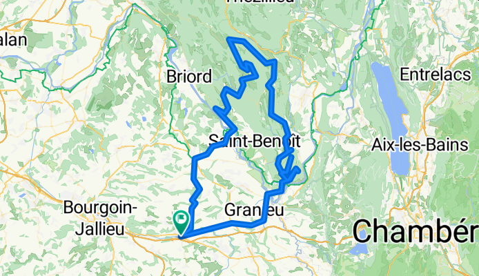
Dans les contreforts du Bugey
A cycling route starting in La Tour-du-Pin, Auvergne-Rhône-Alpes, France.
Overview
About this route
Parcours passant par le golet du Géla, le col d'Izieu, le pas de la Roche, le col de Prémeyzel, le col du Sansonnet, le grand perthuis, le col du petit Perthuis, le col des Fosses et le golet du Tilleul.
Possibilité de passer également par "le golet" noté poussage facile au nord de Saint Germain
- -:--
- Duration
- 129.9 km
- Distance
- 1,756 m
- Ascent
- 1,756 m
- Descent
- ---
- Avg. speed
- ---
- Max. altitude
Route highlights
Points of interest along the route
Point of interest after 27.7 km
Le golet du Géla
Point of interest after 37.1 km
Col d'Izieu
Point of interest after 42.4 km
Pas de la roche
Point of interest after 46.2 km
Col de Prémeyzel
Point of interest after 53.6 km
Col du Sansonnet
Point of interest after 61.7 km
le golet
Point of interest after 82.3 km
Le grand Pertuis
Point of interest after 85.2 km
Col du petit Perthuis
Point of interest after 91.2 km
Col des Fosses
Point of interest after 102.4 km
Golet du Tilleul
Continue with Bikemap
Use, edit, or download this cycling route
You would like to ride Dans les contreforts du Bugey or customize it for your own trip? Here is what you can do with this Bikemap route:
Free features
- Save this route as favorite or in collections
- Copy & plan your own version of this route
- Split it into stages to create a multi-day tour
- Sync your route with Garmin or Wahoo
Premium features
Free trial for 3 days, or one-time payment. More about Bikemap Premium.
- Navigate this route on iOS & Android
- Export a GPX / KML file of this route
- Create your custom printout (try it for free)
- Download this route for offline navigation
Discover more Premium features.
Get Bikemap PremiumFrom our community
Other popular routes starting in La Tour-du-Pin
 16 chemin de l étang à 12 rue pierre Durand
- Distance
- 27.5 km
- Ascent
- 249 m
- Descent
- 295 m
- Location
- La Tour-du-Pin, Auvergne-Rhône-Alpes, France
 Tour de France 2020 Étape 16 : La Tour du Pin 》 Villard de Lans : Côte 2000
- Distance
- 168.6 km
- Ascent
- 4,390 m
- Descent
- 3,475 m
- Location
- La Tour-du-Pin, Auvergne-Rhône-Alpes, France
 Tour-du-Pin Morestel Cremieu Verpilliere
- Distance
- 59.2 km
- Ascent
- 357 m
- Descent
- 468 m
- Location
- La Tour-du-Pin, Auvergne-Rhône-Alpes, France
 2015-04-13-TrainingPras
- Distance
- 8.3 km
- Ascent
- 126 m
- Descent
- 126 m
- Location
- La Tour-du-Pin, Auvergne-Rhône-Alpes, France
 PNS 2014/04/26
- Distance
- 18.4 km
- Ascent
- 191 m
- Descent
- 192 m
- Location
- La Tour-du-Pin, Auvergne-Rhône-Alpes, France
 Paladru 45 km
- Distance
- 46.1 km
- Ascent
- 686 m
- Descent
- 687 m
- Location
- La Tour-du-Pin, Auvergne-Rhône-Alpes, France
 Dans les contreforts du Bugey
- Distance
- 129.9 km
- Ascent
- 1,756 m
- Descent
- 1,756 m
- Location
- La Tour-du-Pin, Auvergne-Rhône-Alpes, France
 La Tour-du-Pin to Saint-Marcelling
- Distance
- 62 km
- Ascent
- 890 m
- Descent
- 924 m
- Location
- La Tour-du-Pin, Auvergne-Rhône-Alpes, France
Open it in the app