

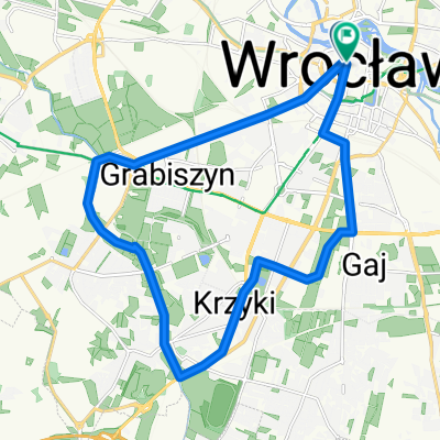
Wrocław - Wymysłowo
A cycling route starting in Wroclaw, Lower Silesian Voivodeship, Poland.
Overview
About this route
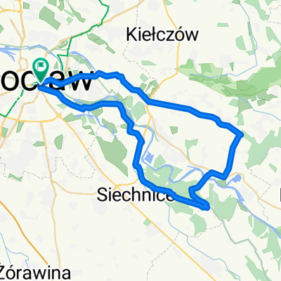
Wrocław - Kołobrzeg dzień 1
Trasa prowadzi po szlakach rowerowych i mało ruchliwych drogach publicznych. Przechodzi przez Wzgórza Trzebnickie i Park Krajobrazowy Dolina Baryczy.
Dłuższy opis na majatravels.com/pl/wroclaw-kolobrzeg-rowerem-dzien-1/
- -:--
- Duration
- 116.4 km
- Distance
- 440 m
- Ascent
- 434 m
- Descent
- ---
- Avg. speed
- ---
- Max. altitude

Route quality
Waytypes & surfaces along the route
Waytypes
Road
37.2 km
(32 %)
Quiet road
36.1 km
(31 %)
Surfaces
Paved
87.3 km
(75 %)
Unpaved
12.8 km
(11 %)
Asphalt
82.6 km
(71 %)
Ground
8.1 km
(7 %)
Continue with Bikemap
Use, edit, or download this cycling route
You would like to ride Wrocław - Wymysłowo or customize it for your own trip? Here is what you can do with this Bikemap route:
Free features
- Save this route as favorite or in collections
- Copy & plan your own version of this route
- Split it into stages to create a multi-day tour
- Sync your route with Garmin or Wahoo
Premium features
Free trial for 3 days, or one-time payment. More about Bikemap Premium.
- Navigate this route on iOS & Android
- Export a GPX / KML file of this route
- Create your custom printout (try it for free)
- Download this route for offline navigation
Discover more Premium features.
Get Bikemap PremiumFrom our community
Other popular routes starting in Wroclaw
 jeziorko dziewicze przez brochów
- Distance
- 40.1 km
- Ascent
- 41 m
- Descent
- 41 m
- Location
- Wroclaw, Lower Silesian Voivodeship, Poland
 Rekreacyjna v3
- Distance
- 33.9 km
- Ascent
- 51 m
- Descent
- 51 m
- Location
- Wroclaw, Lower Silesian Voivodeship, Poland
 Generała Romualda Traugutta 88, Wrocław do Generała Romualda Traugutta 90, Wrocław
- Distance
- 41.6 km
- Ascent
- 37 m
- Descent
- 74 m
- Location
- Wroclaw, Lower Silesian Voivodeship, Poland
 na browara do Chrząstawy
- Distance
- 64.7 km
- Ascent
- 92 m
- Descent
- 87 m
- Location
- Wroclaw, Lower Silesian Voivodeship, Poland
 parki wroclawia
- Distance
- 17.8 km
- Ascent
- 50 m
- Descent
- 51 m
- Location
- Wroclaw, Lower Silesian Voivodeship, Poland
 NUWR 10/04/2018
- Distance
- 45.2 km
- Ascent
- 37 m
- Descent
- 35 m
- Location
- Wroclaw, Lower Silesian Voivodeship, Poland
 Wickedddd
- Distance
- 32.1 km
- Ascent
- 67 m
- Descent
- 66 m
- Location
- Wroclaw, Lower Silesian Voivodeship, Poland
 wro-mietkow-wro
- Distance
- 93.2 km
- Ascent
- 93 m
- Descent
- 90 m
- Location
- Wroclaw, Lower Silesian Voivodeship, Poland
Open it in the app