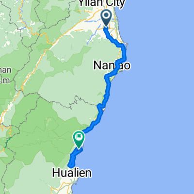
北宜公路
A cycling route starting in Yilan, Taiwan, Taiwan.
Overview
About this route
- -:--
- Duration
- 57.4 km
- Distance
- 954 m
- Ascent
- 951 m
- Descent
- ---
- Avg. speed
- ---
- Avg. speed
Route quality
Waytypes & surfaces along the route
Waytypes
Busy road
56.7 km
(99 %)
Pedestrian area
0.4 km
(<1 %)
Surfaces
Paved
56.7 km
(99 %)
Asphalt
56.7 km
(99 %)
Undefined
0.7 km
(1 %)
Continue with Bikemap
Use, edit, or download this cycling route
You would like to ride 北宜公路 or customize it for your own trip? Here is what you can do with this Bikemap route:
Free features
- Save this route as favorite or in collections
- Copy & plan your own version of this route
- Sync your route with Garmin or Wahoo
Premium features
Free trial for 3 days, or one-time payment. More about Bikemap Premium.
- Navigate this route on iOS & Android
- Export a GPX / KML file of this route
- Create your custom printout (try it for free)
- Download this route for offline navigation
Discover more Premium features.
Get Bikemap PremiumFrom our community
Other popular routes starting in Yilan
- 北濱公路 : 宜蘭市->內湖 101km
- Distance
- 101.7 km
- Ascent
- 567 m
- Descent
- 550 m
- Location
- Yilan, Taiwan, Taiwan
- route1
- Distance
- 1,086.7 km
- Ascent
- 13,550 m
- Descent
- 13,526 m
- Location
- Yilan, Taiwan, Taiwan
- Luodong to Keelong
- Distance
- 105.1 km
- Ascent
- 326 m
- Descent
- 324 m
- Location
- Yilan, Taiwan, Taiwan
- Day 9 Tai Wan
- Distance
- 81.8 km
- Ascent
- 228 m
- Descent
- 180 m
- Location
- Yilan, Taiwan, Taiwan
- 2011青春卡打車~冬山河→五結大閘門
- Distance
- 25.2 km
- Ascent
- 28 m
- Descent
- 30 m
- Location
- Yilan, Taiwan, Taiwan
- 北宜公路
- Distance
- 57.4 km
- Ascent
- 954 m
- Descent
- 951 m
- Location
- Yilan, Taiwan, Taiwan
- 小鐵人宜蘭兩日20160424
- Distance
- 63.8 km
- Ascent
- 1,085 m
- Descent
- 1,078 m
- Location
- Yilan, Taiwan, Taiwan
- 北濱公路
- Distance
- 155.9 km
- Ascent
- 368 m
- Descent
- 367 m
- Location
- Yilan, Taiwan, Taiwan