
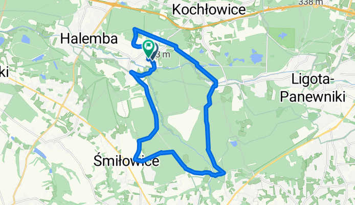
Pętla Jamna 20km
A cycling route starting in Ruda Śląska, Silesian Voivodeship, Poland.
Overview
About this route
- 1 h 21 min
- Duration
- 19.9 km
- Distance
- 213 m
- Ascent
- 238 m
- Descent
- 14.7 km/h
- Avg. speed
- 298 m
- Max. altitude
Route quality
Waytypes & surfaces along the route
Waytypes
Track
12.1 km
(61 %)
Quiet road
6.9 km
(35 %)
Surfaces
Paved
4.9 km
(25 %)
Unpaved
9.9 km
(50 %)
Ground
7.9 km
(40 %)
Asphalt
4.6 km
(23 %)
Continue with Bikemap
Use, edit, or download this cycling route
You would like to ride Pętla Jamna 20km or customize it for your own trip? Here is what you can do with this Bikemap route:
Free features
- Save this route as favorite or in collections
- Copy & plan your own version of this route
- Sync your route with Garmin or Wahoo
Premium features
Free trial for 3 days, or one-time payment. More about Bikemap Premium.
- Navigate this route on iOS & Android
- Export a GPX / KML file of this route
- Create your custom printout (try it for free)
- Download this route for offline navigation
Discover more Premium features.
Get Bikemap PremiumFrom our community
Other popular routes starting in Ruda Śląska
 Ruda Śl. Liebherra - Katowice Kuźnicka - Ruda Śl. Poniatowskiego - Ruda Śl. Liebherra - "Ósemka"
- Distance
- 15.3 km
- Ascent
- 135 m
- Descent
- 132 m
- Location
- Ruda Śląska, Silesian Voivodeship, Poland
 Rynek-Przystań-Starganiec-StarganiecRybaczówka-Rynek
- Distance
- 23.2 km
- Ascent
- 130 m
- Descent
- 127 m
- Location
- Ruda Śląska, Silesian Voivodeship, Poland
 Ruda Śląska H. Liebherra - Mikołów Jamna - Starganiec - Katowice Piotrowice Park Zadole - Stare Panewniki - Ruda Śląska Stara Kuźnica - Ruda Śl. H. Liebherra
- Distance
- 30.6 km
- Ascent
- 195 m
- Descent
- 196 m
- Location
- Ruda Śląska, Silesian Voivodeship, Poland
 Orlen-Rybaczówka browar-buczyna-Orlen
- Distance
- 18.7 km
- Ascent
- 172 m
- Descent
- 166 m
- Location
- Ruda Śląska, Silesian Voivodeship, Poland
 bielszo trials i banhoff
- Distance
- 21.1 km
- Ascent
- 161 m
- Descent
- 168 m
- Location
- Ruda Śląska, Silesian Voivodeship, Poland
 Do Chudowa
- Distance
- 28.9 km
- Ascent
- 86 m
- Descent
- 85 m
- Location
- Ruda Śląska, Silesian Voivodeship, Poland
 Pętla Jamna 20km
- Distance
- 19.9 km
- Ascent
- 213 m
- Descent
- 238 m
- Location
- Ruda Śląska, Silesian Voivodeship, Poland
 Pętla przez Wyry
- Distance
- 54.8 km
- Ascent
- 248 m
- Descent
- 250 m
- Location
- Ruda Śląska, Silesian Voivodeship, Poland
Open it in the app