

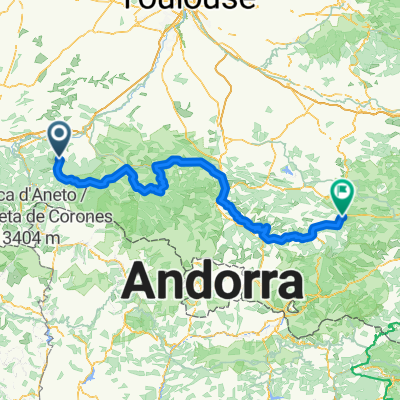
Pyrenäen Tag 5: Saint Lary nach Tarascon
A cycling route starting in Aspet, Occitanie, France.
Overview
About this route
Valle de Bethmale
Col de la Core
Col de Latrape
Col d Agnes
Port de Lers
- -:--
- Duration
- 111.8 km
- Distance
- 2,427 m
- Ascent
- 2,647 m
- Descent
- ---
- Avg. speed
- ---
- Max. altitude

Route quality
Waytypes & surfaces along the route
Waytypes
Road
1.1 km
(1 %)
Quiet road
1.1 km
(1 %)
Surfaces
Paved
57 km
(51 %)
Asphalt
57 km
(51 %)
Undefined
54.8 km
(49 %)
Continue with Bikemap
Use, edit, or download this cycling route
You would like to ride Pyrenäen Tag 5: Saint Lary nach Tarascon or customize it for your own trip? Here is what you can do with this Bikemap route:
Free features
- Save this route as favorite or in collections
- Copy & plan your own version of this route
- Split it into stages to create a multi-day tour
- Sync your route with Garmin or Wahoo
Premium features
Free trial for 3 days, or one-time payment. More about Bikemap Premium.
- Navigate this route on iOS & Android
- Export a GPX / KML file of this route
- Create your custom printout (try it for free)
- Download this route for offline navigation
Discover more Premium features.
Get Bikemap PremiumFrom our community
Other popular routes starting in Aspet
 Ride Day 14—24 Sept 2005—09800 Saint-Lary to 09000 Col des Marrous – Le Bosc – Foix
- Distance
- 62.7 km
- Ascent
- 1,118 m
- Descent
- 809 m
- Location
- Aspet, Occitanie, France
 AAA Pyrenäen 5
- Distance
- 100 km
- Ascent
- 2,476 m
- Descent
- 2,343 m
- Location
- Aspet, Occitanie, France
 Fronsac - Bielle
- Distance
- 209.3 km
- Ascent
- 5,029 m
- Descent
- 5,058 m
- Location
- Aspet, Occitanie, France
 Circuit n° 1 :St Béat/Balès/Portillon/St Béat 93Km
- Distance
- 93 km
- Ascent
- 2,939 m
- Descent
- 2,600 m
- Location
- Aspet, Occitanie, France
 Fr2022 11_Chaum-La Vella
- Distance
- 146.8 km
- Ascent
- 4,141 m
- Descent
- 3,614 m
- Location
- Aspet, Occitanie, France
 Pyrenäen Tag 5: Saint Lary nach Tarascon
- Distance
- 111.8 km
- Ascent
- 2,427 m
- Descent
- 2,647 m
- Location
- Aspet, Occitanie, France
 Aspet - Axat
- Distance
- 225.4 km
- Ascent
- 3,624 m
- Descent
- 3,623 m
- Location
- Aspet, Occitanie, France
 2012 T5
- Distance
- 113.1 km
- Ascent
- 1,101 m
- Descent
- 1,104 m
- Location
- Aspet, Occitanie, France
Open it in the app