
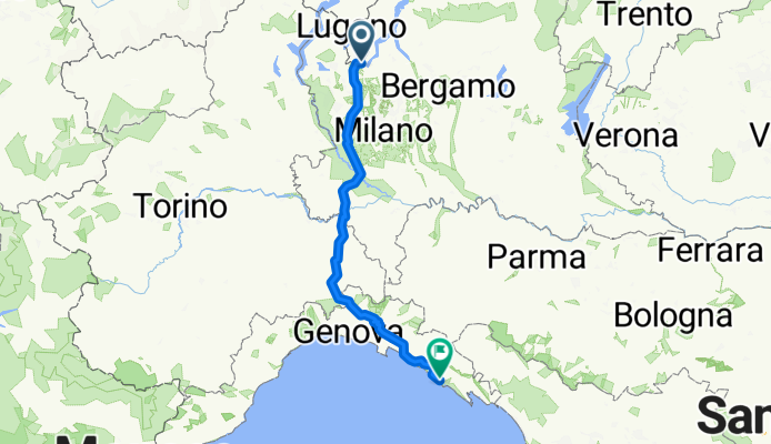
Chiasso - Levanto
A cycling route starting in Maslianico, Lombardy, Italy.
Overview
About this route
- -:--
- Duration
- 299.6 km
- Distance
- 1,688 m
- Ascent
- 1,925 m
- Descent
- ---
- Avg. speed
- ---
- Max. altitude

Route quality
Waytypes & surfaces along the route
Waytypes
Road
89.9 km
(30 %)
Quiet road
68.9 km
(23 %)
Surfaces
Paved
176.8 km
(59 %)
Unpaved
9 km
(3 %)
Asphalt
173.8 km
(58 %)
Unpaved (undefined)
6 km
(2 %)
Continue with Bikemap
Use, edit, or download this cycling route
You would like to ride Chiasso - Levanto or customize it for your own trip? Here is what you can do with this Bikemap route:
Free features
- Save this route as favorite or in collections
- Copy & plan your own version of this route
- Split it into stages to create a multi-day tour
- Sync your route with Garmin or Wahoo
Premium features
Free trial for 3 days, or one-time payment. More about Bikemap Premium.
- Navigate this route on iOS & Android
- Export a GPX / KML file of this route
- Create your custom printout (try it for free)
- Download this route for offline navigation
Discover more Premium features.
Get Bikemap PremiumFrom our community
Other popular routes starting in Maslianico
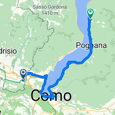
 sacro monte
- Distance
- 33.8 km
- Ascent
- 701 m
- Descent
- 138 m
- Location
- Maslianico, Lombardy, Italy
 Chiasso to Andermatt
- Distance
- 163 km
- Ascent
- 2,243 m
- Descent
- 1,042 m
- Location
- Maslianico, Lombardy, Italy
 giro interno con valbrona
- Distance
- 125.1 km
- Ascent
- 887 m
- Descent
- 881 m
- Location
- Maslianico, Lombardy, Italy
 Chiasso - Parma
- Distance
- 185.5 km
- Ascent
- 250 m
- Descent
- 431 m
- Location
- Maslianico, Lombardy, Italy
 Como-Volpago 1
- Distance
- 79.1 km
- Ascent
- 1,094 m
- Descent
- 1,099 m
- Location
- Maslianico, Lombardy, Italy
 Route zu Alessandria
- Distance
- 485.7 km
- Ascent
- 8,278 m
- Descent
- 8,471 m
- Location
- Maslianico, Lombardy, Italy
 From Nesso to Como to Swiss Border
- Distance
- 31.9 km
- Ascent
- 1,343 m
- Descent
- 1,251 m
- Location
- Maslianico, Lombardy, Italy
 60km Chiasso
- Distance
- 59.8 km
- Ascent
- 872 m
- Descent
- 874 m
- Location
- Maslianico, Lombardy, Italy
Open it in the app