![[DAY 30] Karlsruhe - Mannheim](/_next/static/media/contour-lines-light-small.cafd5e5d.avif)
![[DAY 30] Karlsruhe - Mannheim](https://media.bikemap.net/routes/8670248/staticmaps/in_94719dae-7802-4db4-a5d3-5e69022db527_694x400_bikemap-2021-3D-static.png)
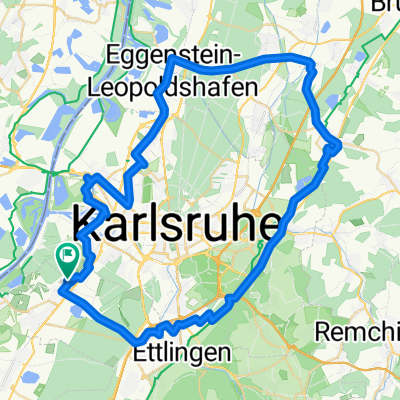
[DAY 30] Karlsruhe - Mannheim
A cycling route starting in Rheinstetten, Baden-Wurttemberg, Germany.
Overview
About this route
- -:--
- Duration
- 85.4 km
- Distance
- 58 m
- Ascent
- 72 m
- Descent
- ---
- Avg. speed
- ---
- Max. altitude

Route photos
![Photo 1 of the Bikemap route "[DAY 30] Karlsruhe - Mannheim"](https://media.bikemap.net/routes/8670248/gallery/thumbs/15f9a61d-1656-4590-9f52-52fc5fa4a7d0.jpeg.688x400_q80_crop.jpg "Photo 1 of the Bikemap route \"[DAY 30] Karlsruhe - Mannheim\"")
![Photo 2 of the Bikemap route "[DAY 30] Karlsruhe - Mannheim"](https://media.bikemap.net/routes/8670248/gallery/thumbs/1dc2a9e2-d19a-4b18-a893-f07e6502711d.jpeg.688x400_q80_crop.jpg "Photo 2 of the Bikemap route \"[DAY 30] Karlsruhe - Mannheim\"")
![Photo 3 of the Bikemap route "[DAY 30] Karlsruhe - Mannheim"](https://media.bikemap.net/routes/8670248/gallery/thumbs/f7295739-8fe4-44c4-b90a-980ad3db0d54.jpeg.208x208_q80_crop.jpg "Photo 3 of the Bikemap route \"[DAY 30] Karlsruhe - Mannheim\"")
![Photo 4 of the Bikemap route "[DAY 30] Karlsruhe - Mannheim"](https://media.bikemap.net/routes/8670248/gallery/thumbs/90433e27-e249-4eaa-be5a-9b2796e82f0a.jpeg.208x208_q80_crop.jpg "Photo 4 of the Bikemap route \"[DAY 30] Karlsruhe - Mannheim\"")
Route quality
Waytypes & surfaces along the route
Waytypes
Track
45.3 km
(53 %)
Path
17.1 km
(20 %)
Surfaces
Paved
77.7 km
(91 %)
Unpaved
1.7 km
(2 %)
Asphalt
75.2 km
(88 %)
Paved (undefined)
1.7 km
(2 %)
Continue with Bikemap
Use, edit, or download this cycling route
You would like to ride [DAY 30] Karlsruhe - Mannheim or customize it for your own trip? Here is what you can do with this Bikemap route:
Free features
- Save this route as favorite or in collections
- Copy & plan your own version of this route
- Split it into stages to create a multi-day tour
- Sync your route with Garmin or Wahoo
Premium features
Free trial for 3 days, or one-time payment. More about Bikemap Premium.
- Navigate this route on iOS & Android
- Export a GPX / KML file of this route
- Create your custom printout (try it for free)
- Download this route for offline navigation
Discover more Premium features.
Get Bikemap PremiumFrom our community
Other popular routes starting in Rheinstetten
![[DAY 30] Karlsruhe - Mannheim](https://media.bikemap.net/routes/8670248/gallery/thumbs/15f9a61d-1656-4590-9f52-52fc5fa4a7d0.jpeg.208x208_q80_crop.jpg) [DAY 30] Karlsruhe - Mannheim
[DAY 30] Karlsruhe - Mannheim- Distance
- 85.4 km
- Ascent
- 58 m
- Descent
- 72 m
- Location
- Rheinstetten, Baden-Wurttemberg, Germany
 aus Rheinstetten in den Kraichgau mit Ortsdurchfahrten von Forchheim - KA Daxlanden - KA Knielingen - Eggenstein - Leopoldshafen - Staffort - Untergrombach - Ob
- Distance
- 112.2 km
- Ascent
- 420 m
- Descent
- 418 m
- Location
- Rheinstetten, Baden-Wurttemberg, Germany
 Radwallfahrt zur St. Annakapelle in Burrweiler mit Einkehrschwung im höchst gelegenen Weingut der Pfalz.
- Distance
- 110.6 km
- Ascent
- 464 m
- Descent
- 464 m
- Location
- Rheinstetten, Baden-Wurttemberg, Germany
 Rheinroute
- Distance
- 80.5 km
- Ascent
- 122 m
- Descent
- 123 m
- Location
- Rheinstetten, Baden-Wurttemberg, Germany
 durch das Murgtal nach Bermersbach, die Rote Lache über den Scherrhof nach Baden-Baden, Balg, Haueneberstein, Kuppenheim und Muggensturm nach Malsch und zurück
- Distance
- 98.7 km
- Ascent
- 678 m
- Descent
- 686 m
- Location
- Rheinstetten, Baden-Wurttemberg, Germany
 Von Rheinstetten zum Campus Nord des KIT
- Distance
- 20.6 km
- Ascent
- 35 m
- Descent
- 37 m
- Location
- Rheinstetten, Baden-Wurttemberg, Germany
 durch das ruhige Nordelsaß - eine Tour durch bodenständige Dörfer mit schönen Fachwerkhäusern.
- Distance
- 96.9 km
- Ascent
- 228 m
- Descent
- 221 m
- Location
- Rheinstetten, Baden-Wurttemberg, Germany
 Rund um die badische Residenz.
- Distance
- 64.9 km
- Ascent
- 161 m
- Descent
- 166 m
- Location
- Rheinstetten, Baden-Wurttemberg, Germany
Open it in the app