

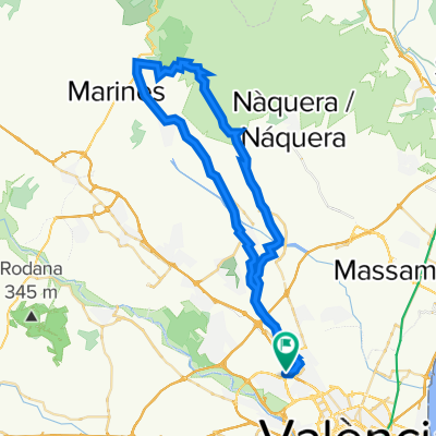
Paterna-Oronet-Estivella-Rotonda Albalat-Garbi por Segart+Alt del PI-Paterna
A cycling route starting in Paterna, Valencia, Spain.
Overview
About this route
Route for the brave, we climb two passes, Oronet and Alt del Pi via Segart. After topping the first (3.5 km at 5%), we descend towards the junction at the El Pla leisure park, Estivella, and direction Albalat until a roundabout indicating Segart. It is recommended to stop before the Albalat roundabout and have something to eat to face the remaining 11 km to the Alt del Pi. There is nothing as tough here as those initial 3 km from Segart: averages of 9%, 13%, 6% respectively with three incredible ramps – 200m at 18%, 200m at 22%, and 200m at 17% until reaching a first rest. The last one and a half kilometres before cresting the Garbi average 5-6% with 150m at 11%. We turn left and summit, a few metres of rest and immediately, on the left, an unmarked track appears leading up to 'the antennas', which given what we have in our legs will be a huge effort to climb. This is the final step: 1.3 km at an average of 12%, with ramps of 17% and barely 30 metres of rest. Without doubt, these two back-to-back climbs are a first category pass with great appeal due to their difficulty and incredible scenery. The return home follows the other side of the Garbi, heading to Serra, Canteras, Bétera... and Paterna.
- -:--
- Duration
- 90 km
- Distance
- 1,063 m
- Ascent
- 1,041 m
- Descent
- ---
- Avg. speed
- ---
- Max. altitude

Route quality
Waytypes & surfaces along the route
Waytypes
Road
50.4 km
(56 %)
Quiet road
33.3 km
(37 %)
Surfaces
Paved
10.8 km
(12 %)
Paved (undefined)
7.2 km
(8 %)
Asphalt
3.6 km
(4 %)
Undefined
79.2 km
(88 %)
Continue with Bikemap
Use, edit, or download this cycling route
You would like to ride Paterna-Oronet-Estivella-Rotonda Albalat-Garbi por Segart+Alt del PI-Paterna or customize it for your own trip? Here is what you can do with this Bikemap route:
Free features
- Save this route as favorite or in collections
- Copy & plan your own version of this route
- Split it into stages to create a multi-day tour
- Sync your route with Garmin or Wahoo
Premium features
Free trial for 3 days, or one-time payment. More about Bikemap Premium.
- Navigate this route on iOS & Android
- Export a GPX / KML file of this route
- Create your custom printout (try it for free)
- Download this route for offline navigation
Discover more Premium features.
Get Bikemap PremiumFrom our community
Other popular routes starting in Paterna
 Terramelar -Chulilla
- Distance
- 163.1 km
- Ascent
- 817 m
- Descent
- 818 m
- Location
- Paterna, Valencia, Spain
 De Carrer Espigol 17, Paterna a Carrer Espigol 17, Paterna
- Distance
- 61.5 km
- Ascent
- 733 m
- Descent
- 741 m
- Location
- Paterna, Valencia, Spain
 san Antonio
- Distance
- 19.7 km
- Ascent
- 319 m
- Descent
- 345 m
- Location
- Paterna, Valencia, Spain
 Alfondeguilla por La Vall d'Uixo
- Distance
- 129.8 km
- Ascent
- 1,270 m
- Descent
- 1,270 m
- Location
- Paterna, Valencia, Spain
 la vallesa
- Distance
- 18.4 km
- Ascent
- 1,131 m
- Descent
- 1,145 m
- Location
- Paterna, Valencia, Spain
 De Carrer Espigol 17, Paterna a Carrer Espigol 17, Paterna
- Distance
- 60.5 km
- Ascent
- 1,471 m
- Descent
- 1,487 m
- Location
- Paterna, Valencia, Spain
 RUTA 1 FINAL TEMPORADA
- Distance
- 153 km
- Ascent
- 1,852 m
- Descent
- 1,893 m
- Location
- Paterna, Valencia, Spain
 De Carrer del Ginebre 3, Paterna a Carrer de les Roses 5, Paterna
- Distance
- 29.4 km
- Ascent
- 239 m
- Descent
- 266 m
- Location
- Paterna, Valencia, Spain
Open it in the app