

Parcour des Graves - Boucle Bleu
A cycling route starting in Léognan, Nouvelle-Aquitaine, France.
Overview
About this route
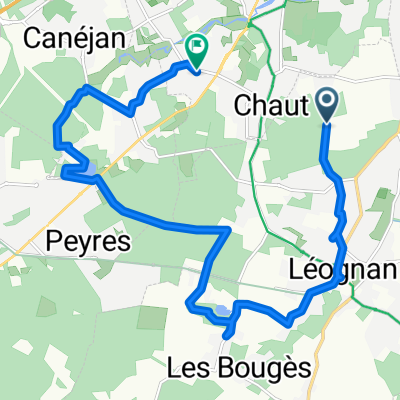
The Blue route is a 20 km loop that allows you to discover the Parc Forestier du Lac Bleu in Léognan, the Lac Vert of Canéjan, the Vineyard and Wine Ecomuseum in Gradignan, the Priory of Cayac in Gradignan, and also the valley of the Eau Bourde. This route is one of the three routes that make up the Graves route (56 km in total) and it crosses 5 municipalities: Léognan, Canéjan, Gradignan, Cestas, and Pessac. This itinerary consists of « natural paths » but also various sections (cycle tracks, communal roads, rural paths…). It is open to walkers and mountain bikes. The other two routes are the green route (5 km) and the red route (30 km).
- -:--
- Duration
- 24.8 km
- Distance
- 84 m
- Ascent
- 86 m
- Descent
- ---
- Avg. speed
- ---
- Max. altitude
Route quality
Waytypes & surfaces along the route
Waytypes
Quiet road
6.4 km
(26 %)
Track
5.5 km
(22 %)
Surfaces
Paved
6.2 km
(25 %)
Unpaved
8.7 km
(35 %)
Asphalt
6.2 km
(25 %)
Gravel
4.2 km
(17 %)
Continue with Bikemap
Use, edit, or download this cycling route
You would like to ride Parcour des Graves - Boucle Bleu or customize it for your own trip? Here is what you can do with this Bikemap route:
Free features
- Save this route as favorite or in collections
- Copy & plan your own version of this route
- Sync your route with Garmin or Wahoo
Premium features
Free trial for 3 days, or one-time payment. More about Bikemap Premium.
- Navigate this route on iOS & Android
- Export a GPX / KML file of this route
- Create your custom printout (try it for free)
- Download this route for offline navigation
Discover more Premium features.
Get Bikemap PremiumFrom our community
Other popular routes starting in Léognan
 Itinéraire sportif en Léognan
- Distance
- 31.9 km
- Ascent
- 192 m
- Descent
- 190 m
- Location
- Léognan, Nouvelle-Aquitaine, France
 5000 Rue du 19 Mars 1962, Léognan à 4 Rue Édouard Michel, Gradignan
- Distance
- 5.9 km
- Ascent
- 29 m
- Descent
- 37 m
- Location
- Léognan, Nouvelle-Aquitaine, France
 tour des graves - gradignan leognan
- Distance
- 16.2 km
- Ascent
- 7 m
- Descent
- 47 m
- Location
- Léognan, Nouvelle-Aquitaine, France
 Le grand prix UCI Pro Tour Bi-hebdomadaire de Leognan
- Distance
- 79.9 km
- Ascent
- 247 m
- Descent
- 228 m
- Location
- Léognan, Nouvelle-Aquitaine, France
 De LEOGNAN à CASTELSARASIN
- Distance
- 352.2 km
- Ascent
- 984 m
- Descent
- 832 m
- Location
- Léognan, Nouvelle-Aquitaine, France
 Home To Work And Back
- Distance
- 9.3 km
- Ascent
- 73 m
- Descent
- 70 m
- Location
- Léognan, Nouvelle-Aquitaine, France
 De Rue des Menhirs 55, Villenave-d'Ornon à Rue des Menhirs 46, Villenave-d'Ornon
- Distance
- 9.6 km
- Ascent
- 74 m
- Descent
- 78 m
- Location
- Léognan, Nouvelle-Aquitaine, France
 Parcour des Graves - Boucle Bleu
- Distance
- 24.8 km
- Ascent
- 84 m
- Descent
- 86 m
- Location
- Léognan, Nouvelle-Aquitaine, France
Open it in the app