Kleine Moutainbike-Runde 01
A cycling route starting in Schömberg, Baden-Wurttemberg, Germany.
Overview
About this route
Short mountain bike loop through the forest in the west of Schömberg.
- 2 h 17 min
- Duration
- 18.8 km
- Distance
- 396 m
- Ascent
- 397 m
- Descent
- 8.2 km/h
- Avg. speed
- ---
- Max. altitude
Continue with Bikemap
Use, edit, or download this cycling route
You would like to ride Kleine Moutainbike-Runde 01 or customize it for your own trip? Here is what you can do with this Bikemap route:
Free features
- Save this route as favorite or in collections
- Copy & plan your own version of this route
- Sync your route with Garmin or Wahoo
Premium features
Free trial for 3 days, or one-time payment. More about Bikemap Premium.
- Navigate this route on iOS & Android
- Export a GPX / KML file of this route
- Create your custom printout (try it for free)
- Download this route for offline navigation
Discover more Premium features.
Get Bikemap PremiumFrom our community
Other popular routes starting in Schömberg
- Ziegler Ice Rider 2016
- Distance
- 9.7 km
- Ascent
- 239 m
- Descent
- 239 m
- Location
- Schömberg, Baden-Wurttemberg, Germany
- Fastroad_Schömberg_Route D
- Distance
- 24.8 km
- Ascent
- 435 m
- Descent
- 422 m
- Location
- Schömberg, Baden-Wurttemberg, Germany
- Einfache Fahrt in Schömberg
- Distance
- 11.3 km
- Ascent
- 197 m
- Descent
- 198 m
- Location
- Schömberg, Baden-Wurttemberg, Germany
- Fahrt zur Arbeit
- Distance
- 20.5 km
- Ascent
- 269 m
- Descent
- 581 m
- Location
- Schömberg, Baden-Wurttemberg, Germany
- Volksbank Pforzheim Ice Runner
- Distance
- 2.3 km
- Ascent
- 33 m
- Descent
- 35 m
- Location
- Schömberg, Baden-Wurttemberg, Germany
- Hengstbergweg 10, Schömberg nach Hanauer Straße 4, Pforzheim
- Distance
- 20.5 km
- Ascent
- 303 m
- Descent
- 615 m
- Location
- Schömberg, Baden-Wurttemberg, Germany
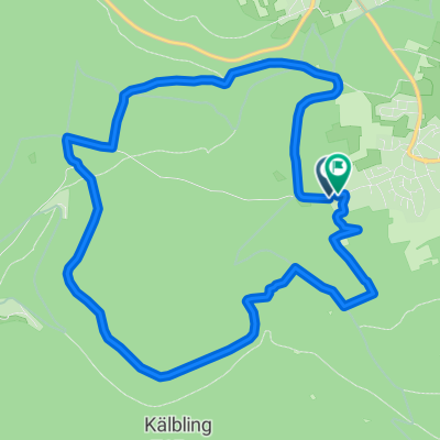
- Heidelbeerpfannkuchen-Route Kapfenhardt - Grünhütte
- Distance
- 52.5 km
- Ascent
- 1,027 m
- Descent
- 1,024 m
- Location
- Schömberg, Baden-Wurttemberg, Germany
- Ice Rider
- Distance
- 10.9 km
- Ascent
- 255 m
- Descent
- 258 m
- Location
- Schömberg, Baden-Wurttemberg, Germany
Open it in the app