

Lichtenrade - Rangsdorf / critdmg
A cycling route starting in Lichtenrade, State of Berlin, Germany.
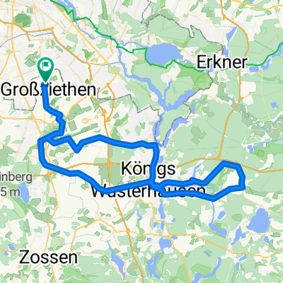
Overview
About this route
Von Lichtenrade, nach Rangsdorf, am Rangsdorfer See Europaweg entlang und zurück über Jühnsdorf.
- -:--
- Duration
- 36.9 km
- Distance
- 95 m
- Ascent
- 93 m
- Descent
- ---
- Avg. speed
- ---
- Max. altitude

Continue with Bikemap
Use, edit, or download this cycling route
You would like to ride Lichtenrade - Rangsdorf / critdmg or customize it for your own trip? Here is what you can do with this Bikemap route:
Free features
- Save this route as favorite or in collections
- Copy & plan your own version of this route
- Sync your route with Garmin or Wahoo
Premium features
Free trial for 3 days, or one-time payment. More about Bikemap Premium.
- Navigate this route on iOS & Android
- Export a GPX / KML file of this route
- Create your custom printout (try it for free)
- Download this route for offline navigation
Discover more Premium features.
Get Bikemap PremiumFrom our community
Other popular routes starting in Lichtenrade
 Lichtenrade - Großziethen
- Distance
- 15.9 km
- Ascent
- 19 m
- Descent
- 19 m
- Location
- Lichtenrade, State of Berlin, Germany
 Mahlow Waßmansdorf Rudow
- Distance
- 23.2 km
- Ascent
- 34 m
- Descent
- 32 m
- Location
- Lichtenrade, State of Berlin, Germany
 Berliner Rand Wege
- Distance
- 19.1 km
- Ascent
- 157 m
- Descent
- 151 m
- Location
- Lichtenrade, State of Berlin, Germany
 flughafen ber 45km
- Distance
- 45.1 km
- Ascent
- 65 m
- Descent
- 65 m
- Location
- Lichtenrade, State of Berlin, Germany
 S Lichtenrade - Groß Schulzendorf - Lüdersdorf - Trebbin - Glau - Schenkenhorst - S Zehlendorf - S/U Bundesplatz
- Distance
- 88.9 km
- Ascent
- 186 m
- Descent
- 185 m
- Location
- Lichtenrade, State of Berlin, Germany
 Lichtenrade-Kienitz
- Distance
- 31.1 km
- Ascent
- 42 m
- Descent
- 45 m
- Location
- Lichtenrade, State of Berlin, Germany
 perm Wenzlow
- Distance
- 82.9 km
- Ascent
- 179 m
- Descent
- 179 m
- Location
- Lichtenrade, State of Berlin, Germany
 Am Feld 1B, Blankenfelde-Mahlow nach Am Feld 1A, Blankenfelde-Mahlow
- Distance
- 34.8 km
- Ascent
- 224 m
- Descent
- 225 m
- Location
- Lichtenrade, State of Berlin, Germany
Open it in the app