

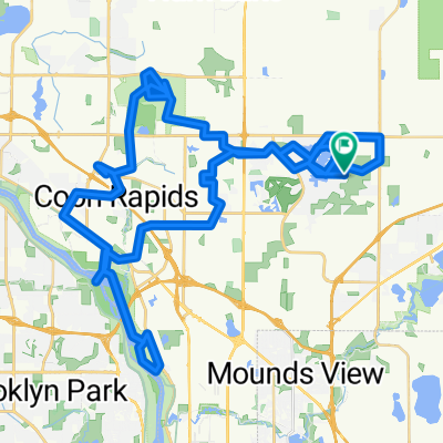
Rice Creek Chain all paved trails & 2 off trails
A cycling route starting in Circle Pines, Minnesota, United States.
Overview
About this route
- -:--
- Duration
- 10.4 km
- Distance
- 42 m
- Ascent
- 43 m
- Descent
- ---
- Avg. speed
- 277 m
- Max. altitude
Route quality
Waytypes & surfaces along the route
Waytypes
Cycleway
5.9 km
(57 %)
Quiet road
3.7 km
(36 %)
Surfaces
Paved
8 km
(77 %)
Unpaved
0.6 km
(6 %)
Asphalt
8 km
(77 %)
Ground
0.6 km
(6 %)
Undefined
1.8 km
(17 %)
Continue with Bikemap
Use, edit, or download this cycling route
You would like to ride Rice Creek Chain all paved trails & 2 off trails or customize it for your own trip? Here is what you can do with this Bikemap route:
Free features
- Save this route as favorite or in collections
- Copy & plan your own version of this route
- Sync your route with Garmin or Wahoo
Premium features
Free trial for 3 days, or one-time payment. More about Bikemap Premium.
- Navigate this route on iOS & Android
- Export a GPX / KML file of this route
- Create your custom printout (try it for free)
- Download this route for offline navigation
Discover more Premium features.
Get Bikemap PremiumFrom our community
Other popular routes starting in Circle Pines
 Rice Creek Chain all paved trails & 2 off trails
- Distance
- 10.4 km
- Ascent
- 42 m
- Descent
- 43 m
- Location
- Circle Pines, Minnesota, United States
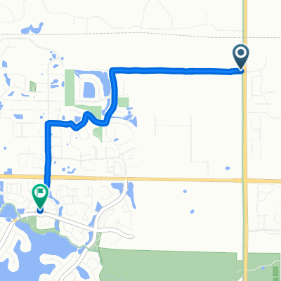
 117th Ln NE, Blaine to 117th Ln NE, Blaine
- Distance
- 76.5 km
- Ascent
- 221 m
- Descent
- 221 m
- Location
- Circle Pines, Minnesota, United States
 4101 131st Ave NE, Blaine to 12283 Flanders St NE, Blaine
- Distance
- 3.9 km
- Ascent
- 6 m
- Descent
- 10 m
- Location
- Circle Pines, Minnesota, United States
 Lions Park
- Distance
- 18.3 km
- Ascent
- 56 m
- Descent
- 58 m
- Location
- Circle Pines, Minnesota, United States
 Steady ride in Lino Lakes
- Distance
- 26.4 km
- Ascent
- 60 m
- Descent
- 59 m
- Location
- Circle Pines, Minnesota, United States
 B2B00324 55014>55413 via Lexington, Co Rd C, Minneapolis Diagonal Trail
- Distance
- 25.2 km
- Ascent
- 66 m
- Descent
- 60 m
- Location
- Circle Pines, Minnesota, United States
 B2B00390 55126>55344 viaHodgson/Victoria/Como/Intercampus/4thSE/StoneArch/CedarTrail/Hopkins/ShadyOak
- Distance
- 51.7 km
- Ascent
- 154 m
- Descent
- 160 m
- Location
- Circle Pines, Minnesota, United States
 202 Elm St, Lino Lakes to 628–630 Town Center Pkwy, Lino Lakes
- Distance
- 5 km
- Ascent
- 30 m
- Descent
- 35 m
- Location
- Circle Pines, Minnesota, United States
Open it in the app