

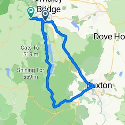
Long Hill from Whalley Bridge
A cycling route starting in Whaley Bridge, England, United Kingdom.
Overview
About this route
A long steady slog of no more than 10% but difficult if windy. Turn right at top to Goyt Valley and the Cat & Fiddle or carry on down to Buxton
- -:--
- Duration
- 7.7 km
- Distance
- 296 m
- Ascent
- 47 m
- Descent
- ---
- Avg. speed
- ---
- Max. altitude

Continue with Bikemap
Use, edit, or download this cycling route
You would like to ride Long Hill from Whalley Bridge or customize it for your own trip? Here is what you can do with this Bikemap route:
Free features
- Save this route as favorite or in collections
- Copy & plan your own version of this route
- Sync your route with Garmin or Wahoo
Premium features
Free trial for 3 days, or one-time payment. More about Bikemap Premium.
- Navigate this route on iOS & Android
- Export a GPX / KML file of this route
- Create your custom printout (try it for free)
- Download this route for offline navigation
Discover more Premium features.
Get Bikemap PremiumFrom our community
Other popular routes starting in Whaley Bridge
 Whaley Bridge / New Mills MTB
- Distance
- 49.7 km
- Ascent
- 1,002 m
- Descent
- 1,011 m
- Location
- Whaley Bridge, England, United Kingdom
 Buxton - West Peak
- Distance
- 25.2 km
- Ascent
- 617 m
- Descent
- 546 m
- Location
- Whaley Bridge, England, United Kingdom
 Hockerley Lane 4, Whaley Bridge to Stockport Road 27, Marple
- Distance
- 10.4 km
- Ascent
- 188 m
- Descent
- 305 m
- Location
- Whaley Bridge, England, United Kingdom
 Bridgemont to James Street School, Thornton
- Distance
- 69.5 km
- Ascent
- 1,392 m
- Descent
- 1,299 m
- Location
- Whaley Bridge, England, United Kingdom
 Bugsworth Basin 60a, Buxworth to Dyche Street 15
- Distance
- 37.6 km
- Ascent
- 223 m
- Descent
- 382 m
- Location
- Whaley Bridge, England, United Kingdom
 Bugsworth Basin 60a, Buxworth to Bugsworth Basin 60a, Buxworth
- Distance
- 65 km
- Ascent
- 570 m
- Descent
- 625 m
- Location
- Whaley Bridge, England, United Kingdom
 Goyt Goyt
- Distance
- 32.5 km
- Ascent
- 615 m
- Descent
- 614 m
- Location
- Whaley Bridge, England, United Kingdom
 Whaley Bridge - Snake Pass - Mam Tor
- Distance
- 79.1 km
- Ascent
- 941 m
- Descent
- 953 m
- Location
- Whaley Bridge, England, United Kingdom
Open it in the app