Alpokalja tanévzáró túra 3. nap
A cycling route starting in Ják, Vas County, Hungary.
Overview
About this route
Felsőcsatár - Csörötnek
- -:--
- Duration
- 51.1 km
- Distance
- 141 m
- Ascent
- 219 m
- Descent
- ---
- Avg. speed
- ---
- Max. altitude
Route quality
Waytypes & surfaces along the route
Waytypes
Road
15.3 km
(30 %)
Quiet road
6.6 km
(13 %)
Surfaces
Paved
11.2 km
(22 %)
Unpaved
1 km
(2 %)
Asphalt
10.7 km
(21 %)
Ground
1 km
(2 %)
Continue with Bikemap
Use, edit, or download this cycling route
You would like to ride Alpokalja tanévzáró túra 3. nap or customize it for your own trip? Here is what you can do with this Bikemap route:
Free features
- Save this route as favorite or in collections
- Copy & plan your own version of this route
- Sync your route with Garmin or Wahoo
Premium features
Free trial for 3 days, or one-time payment. More about Bikemap Premium.
- Navigate this route on iOS & Android
- Export a GPX / KML file of this route
- Create your custom printout (try it for free)
- Download this route for offline navigation
Discover more Premium features.
Get Bikemap PremiumFrom our community
Other popular routes starting in Ják
- 40Km/h
- Distance
- 51.3 km
- Ascent
- 134 m
- Descent
- 134 m
- Location
- Ják, Vas County, Hungary
- Ják-Szentpéterfa-Güssing-Szombathely
- Distance
- 73.7 km
- Ascent
- 2,181 m
- Descent
- 2,211 m
- Location
- Ják, Vas County, Hungary
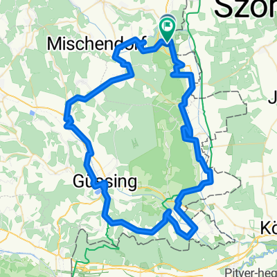
- Deutsch Schützen - Güssing u. retour
- Distance
- 48.5 km
- Ascent
- 261 m
- Descent
- 265 m
- Location
- Ják, Vas County, Hungary
- "B57 Weinidylle" kerékpárút részlet :)
- Distance
- 78.4 km
- Ascent
- 386 m
- Descent
- 389 m
- Location
- Ják, Vas County, Hungary
- Vas megye összes települése ab
- Distance
- 1,090.6 km
- Ascent
- 779 m
- Descent
- 779 m
- Location
- Ják, Vas County, Hungary
- Ják-Balogunyom-Ják
- Distance
- 3.4 km
- Ascent
- 0 m
- Descent
- 8 m
- Location
- Ják, Vas County, Hungary
- Eisenberg - Neustift /L
- Distance
- 77.1 km
- Ascent
- 597 m
- Descent
- 577 m
- Location
- Ják, Vas County, Hungary
- Nárai-Szentpéterfa-Ják
- Distance
- 33.3 km
- Ascent
- 120 m
- Descent
- 120 m
- Location
- Ják, Vas County, Hungary
Open it in the app