

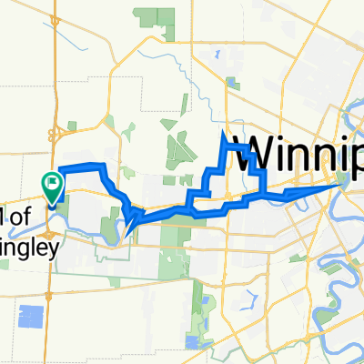
G and Julie Route
A cycling route starting in Headingley, Manitoba, Canada.
Overview
About this route
The route I take downtown to visit some friends and then make my way back. The options are endless on this route if I make it a liesure day. Start early and visit Corydon Village going or returning home. Assiniboine Park is always a must. River trails and the Forks option!!!
- -:--
- Duration
- 37.9 km
- Distance
- 30 m
- Ascent
- 33 m
- Descent
- ---
- Avg. speed
- ---
- Max. altitude

Route quality
Waytypes & surfaces along the route
Waytypes
Cycleway
19.3 km
(51 %)
Quiet road
15.2 km
(40 %)
Surfaces
Paved
18.6 km
(49 %)
Unpaved
11.4 km
(30 %)
Asphalt
12.9 km
(34 %)
Gravel
9.9 km
(26 %)
Continue with Bikemap
Use, edit, or download this cycling route
You would like to ride G and Julie Route or customize it for your own trip? Here is what you can do with this Bikemap route:
Free features
- Save this route as favorite or in collections
- Copy & plan your own version of this route
- Sync your route with Garmin or Wahoo
Premium features
Free trial for 3 days, or one-time payment. More about Bikemap Premium.
- Navigate this route on iOS & Android
- Export a GPX / KML file of this route
- Create your custom printout (try it for free)
- Download this route for offline navigation
Discover more Premium features.
Get Bikemap PremiumFrom our community
Other popular routes starting in Headingley
 Headingly Grand Trunk Lido Plage Route
- Distance
- 38.3 km
- Ascent
- 4 m
- Descent
- 4 m
- Location
- Headingley, Manitoba, Canada
 327 Hillary Bay, Winnipeg to 327 Hillary Bay, Winnipeg
- Distance
- 1.1 km
- Ascent
- 24 m
- Descent
- 35 m
- Location
- Headingley, Manitoba, Canada
 Harte - Assiniboine - Roblin - Westdale
- Distance
- 22.6 km
- Ascent
- 12 m
- Descent
- 13 m
- Location
- Headingley, Manitoba, Canada
 6 Jeannette Bay, Winnipeg to 6 Jeannette Bay, Winnipeg
- Distance
- 43.5 km
- Ascent
- 150 m
- Descent
- 149 m
- Location
- Headingley, Manitoba, Canada
 G and Julie Route
- Distance
- 37.9 km
- Ascent
- 30 m
- Descent
- 33 m
- Location
- Headingley, Manitoba, Canada
 Harstone Road 524, Winnipeg to Harstone Road 524, Winnipeg
- Distance
- 13.7 km
- Ascent
- 47 m
- Descent
- 45 m
- Location
- Headingley, Manitoba, Canada
 Dumore Bay 11, Winnipeg to Roblin Boulevard 7130, Headingley
- Distance
- 24.4 km
- Ascent
- 58 m
- Descent
- 62 m
- Location
- Headingley, Manitoba, Canada
 Harte Trail - Beudry Park Ride
- Distance
- 24 km
- Ascent
- 0 m
- Descent
- 4 m
- Location
- Headingley, Manitoba, Canada
Open it in the app