
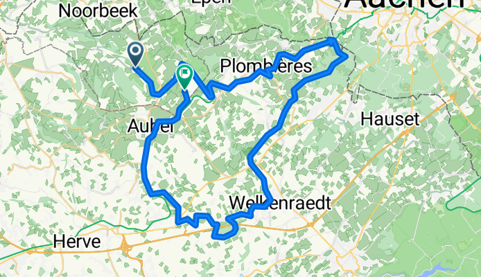
Hombourg- 3 landenpunt enz
A cycling route starting in Sint-Pieters-Voeren, Flemish Region, Belgium.
Overview
About this route
Hoogtepunten: letterlijk Hombourg station- 3 landenpunt ( via ravels behalve 3 haarspeldbochten) Brug van montzen (gigantisch) Welkenraedt- Clermont (schoonste dorp van Wallonie) en via Ravel terug .
Voordeel Ravels is niet te stijl.
- -:--
- Duration
- 55.5 km
- Distance
- 550 m
- Ascent
- 490 m
- Descent
- ---
- Avg. speed
- ---
- Max. altitude
Route quality
Waytypes & surfaces along the route
Waytypes
Quiet road
17.5 km
(31 %)
Path
11.3 km
(20 %)
Surfaces
Paved
30.7 km
(55 %)
Unpaved
10.7 km
(19 %)
Asphalt
30.1 km
(54 %)
Loose gravel
5.4 km
(10 %)
Continue with Bikemap
Use, edit, or download this cycling route
You would like to ride Hombourg- 3 landenpunt enz or customize it for your own trip? Here is what you can do with this Bikemap route:
Free features
- Save this route as favorite or in collections
- Copy & plan your own version of this route
- Sync your route with Garmin or Wahoo
Premium features
Free trial for 3 days, or one-time payment. More about Bikemap Premium.
- Navigate this route on iOS & Android
- Export a GPX / KML file of this route
- Create your custom printout (try it for free)
- Download this route for offline navigation
Discover more Premium features.
Get Bikemap PremiumFrom our community
Other popular routes starting in Sint-Pieters-Voeren
 Voeren-eijsden-Kanne-Jekervallai-Eben Emaël-via Hallembaye en Visé terug
- Distance
- 45.9 km
- Ascent
- 159 m
- Descent
- 243 m
- Location
- Sint-Pieters-Voeren, Flemish Region, Belgium
 Ronde van Voeren
- Distance
- 138.3 km
- Ascent
- 1,077 m
- Descent
- 1,077 m
- Location
- Sint-Pieters-Voeren, Flemish Region, Belgium
 ANWB route
- Distance
- 41.5 km
- Ascent
- 556 m
- Descent
- 626 m
- Location
- Sint-Pieters-Voeren, Flemish Region, Belgium
 Voeren - Maas Rundweg
- Distance
- 35.8 km
- Ascent
- 215 m
- Descent
- 215 m
- Location
- Sint-Pieters-Voeren, Flemish Region, Belgium
 Bassenge en terug
- Distance
- 53.7 km
- Ascent
- 360 m
- Descent
- 372 m
- Location
- Sint-Pieters-Voeren, Flemish Region, Belgium
 Happen Trappen Voeren
- Distance
- 40.8 km
- Ascent
- 472 m
- Descent
- 461 m
- Location
- Sint-Pieters-Voeren, Flemish Region, Belgium
 Hombourg- 3 landenpunt enz
- Distance
- 55.5 km
- Ascent
- 550 m
- Descent
- 490 m
- Location
- Sint-Pieters-Voeren, Flemish Region, Belgium
 Via Ligne 38 et Fort de Battice
- Distance
- 38.2 km
- Ascent
- 338 m
- Descent
- 338 m
- Location
- Sint-Pieters-Voeren, Flemish Region, Belgium
Open it in the app