

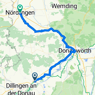
Höchstädt - Katzenstein
A cycling route starting in Höchstädt an der Donau, Bavaria, Germany.
Overview
About this route
- -:--
- Duration
- 58.3 km
- Distance
- 0 m
- Ascent
- 0 m
- Descent
- ---
- Avg. speed
- ---
- Max. altitude
Route quality
Waytypes & surfaces along the route
Waytypes
Track
27.4 km
(47 %)
Path
10.5 km
(18 %)
Surfaces
Paved
23.9 km
(41 %)
Unpaved
21.6 km
(37 %)
Asphalt
21 km
(36 %)
Gravel
18.7 km
(32 %)
Continue with Bikemap
Use, edit, or download this cycling route
You would like to ride Höchstädt - Katzenstein or customize it for your own trip? Here is what you can do with this Bikemap route:
Free features
- Save this route as favorite or in collections
- Copy & plan your own version of this route
- Sync your route with Garmin or Wahoo
Premium features
Free trial for 3 days, or one-time payment. More about Bikemap Premium.
- Navigate this route on iOS & Android
- Export a GPX / KML file of this route
- Create your custom printout (try it for free)
- Download this route for offline navigation
Discover more Premium features.
Get Bikemap PremiumFrom our community
Other popular routes starting in Höchstädt an der Donau
 201405-04 Iller - Donau - Zusam Höchstädt - Zusam - Markt Wald
- Distance
- 75.1 km
- Ascent
- 428 m
- Descent
- 214 m
- Location
- Höchstädt an der Donau, Bavaria, Germany
 NSR-180km 2008
- Distance
- 181.2 km
- Ascent
- 1,504 m
- Descent
- 1,488 m
- Location
- Höchstädt an der Donau, Bavaria, Germany
 NSR-72km 2008
- Distance
- 76.9 km
- Ascent
- 590 m
- Descent
- 579 m
- Location
- Höchstädt an der Donau, Bavaria, Germany
 Zügle - Wertingen-Mertingen
- Distance
- 63.1 km
- Ascent
- 8,820 m
- Descent
- 9,240 m
- Location
- Höchstädt an der Donau, Bavaria, Germany
 UT 05-2023: Höchstädt a.d. Donau - Nördlingen
- Distance
- 56.9 km
- Ascent
- 322 m
- Descent
- 302 m
- Location
- Höchstädt an der Donau, Bavaria, Germany
 D08 Höchstädt - Neuburg
- Distance
- 72.3 km
- Ascent
- 236 m
- Descent
- 278 m
- Location
- Höchstädt an der Donau, Bavaria, Germany
 NSR-110 2008
- Distance
- 119.7 km
- Ascent
- 1,021 m
- Descent
- 986 m
- Location
- Höchstädt an der Donau, Bavaria, Germany
 18. etapa Hochstadt an der Donau - Ulm 60km
- Distance
- 58.4 km
- Ascent
- 89 m
- Descent
- 29 m
- Location
- Höchstädt an der Donau, Bavaria, Germany
Open it in the app