

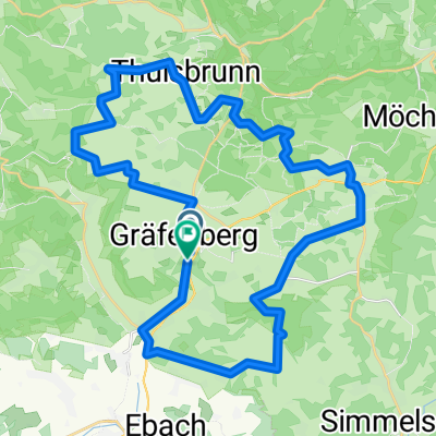
Gräfenberg-Rüsselbach
A cycling route starting in Gräfenberg, Bavaria, Germany.
Overview
About this route
About Thuisbrunn & Untertrubach
- -:--
- Duration
- 25.9 km
- Distance
- 431 m
- Ascent
- 495 m
- Descent
- ---
- Avg. speed
- ---
- Max. altitude

Route quality
Waytypes & surfaces along the route
Waytypes
Track
9.6 km
(37 %)
Quiet road
8.3 km
(32 %)
Surfaces
Paved
11.7 km
(45 %)
Unpaved
8.3 km
(32 %)
Asphalt
9.6 km
(37 %)
Gravel
3.6 km
(14 %)
Continue with Bikemap
Use, edit, or download this cycling route
You would like to ride Gräfenberg-Rüsselbach or customize it for your own trip? Here is what you can do with this Bikemap route:
Free features
- Save this route as favorite or in collections
- Copy & plan your own version of this route
- Sync your route with Garmin or Wahoo
Premium features
Free trial for 3 days, or one-time payment. More about Bikemap Premium.
- Navigate this route on iOS & Android
- Export a GPX / KML file of this route
- Create your custom printout (try it for free)
- Download this route for offline navigation
Discover more Premium features.
Get Bikemap PremiumFrom our community
Other popular routes starting in Gräfenberg
 Gräfenberg-Rüsselbach
- Distance
- 25.9 km
- Ascent
- 431 m
- Descent
- 495 m
- Location
- Gräfenberg, Bavaria, Germany
 Brauerei_-_Tour_FO_7
- Distance
- 38.9 km
- Ascent
- 623 m
- Descent
- 623 m
- Location
- Gräfenberg, Bavaria, Germany
 Kasberg 8, Gräfenberg nach Kasberg 8, Gräfenberg
- Distance
- 4.3 km
- Ascent
- 59 m
- Descent
- 60 m
- Location
- Gräfenberg, Bavaria, Germany
 20161122_094638.gpx
- Distance
- 14.4 km
- Ascent
- 305 m
- Descent
- 302 m
- Location
- Gräfenberg, Bavaria, Germany
 Gräfenbergbahn erkunden
- Distance
- 37.2 km
- Ascent
- 208 m
- Descent
- 350 m
- Location
- Gräfenberg, Bavaria, Germany
 Lillachtal
- Distance
- 20.8 km
- Ascent
- 375 m
- Descent
- 375 m
- Location
- Gräfenberg, Bavaria, Germany
 Oberlandtour
- Distance
- 33.9 km
- Ascent
- 594 m
- Descent
- 596 m
- Location
- Gräfenberg, Bavaria, Germany
 Gräfenberg_Lillachquelle_Leidstein_Vogelherd
- Distance
- 28.7 km
- Ascent
- 536 m
- Descent
- 546 m
- Location
- Gräfenberg, Bavaria, Germany
Open it in the app