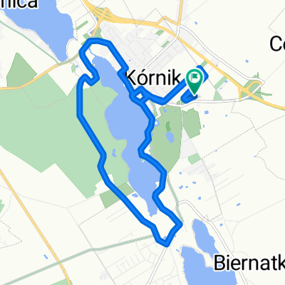
K贸rnik - Zaniemy艣l - Czmoniec
A cycling route starting in K贸rnik, Greater Poland Voivodeship, Poland.
Overview
About this route
K贸rnik - Bnin - B艂a偶ejewko - Zaniemy艣l - Mechlin - Zbrudzewo - Czmoniec - Radzewo - Bnin - K贸rnik
- -:--
- Duration
- 55.2 km
- Distance
- 97 m
- Ascent
- 97 m
- Descent
- ---
- Avg. speed
- ---
- Max. altitude
Continue with Bikemap
Use, edit, or download this cycling route
You would like to ride K贸rnik - Zaniemy艣l - Czmoniec or customize it for your own trip? Here is what you can do with this Bikemap route:
Free features
- Save this route as favorite or in collections
- Copy & plan your own version of this route
- Sync your route with Garmin or Wahoo
Premium features
Free trial for 3 days, or one-time payment. More about Bikemap Premium.
- Navigate this route on iOS & Android
- Export a GPX / KML file of this route
- Create your custom printout (try it for free)
- Download this route for offline navigation
Discover more Premium features.
Get Bikemap PremiumFrom our community
Other popular routes starting in K贸rnik
- Almost Springtime
- Distance
- 28.8 km
- Ascent
- 39 m
- Descent
- 36 m
- Location
- K贸rnik, Greater Poland Voivodeship, Poland
- Niedzielny poranek
- Distance
- 45.1 km
- Ascent
- 68 m
- Descent
- 71 m
- Location
- K贸rnik, Greater Poland Voivodeship, Poland
- Bnin - Herman贸w
- Distance
- 62.1 km
- Ascent
- 101 m
- Descent
- 97 m
- Location
- K贸rnik, Greater Poland Voivodeship, Poland
- Pozna艅ska 77, K贸rnik do Romana Maya 127A, Pozna艅
- Distance
- 20 km
- Ascent
- 129 m
- Descent
- 130 m
- Location
- K贸rnik, Greater Poland Voivodeship, Poland
- Powolna trasa w K贸rnik
- Distance
- 12 km
- Ascent
- 73 m
- Descent
- 72 m
- Location
- K贸rnik, Greater Poland Voivodeship, Poland
- Pogorzelica-przeprawa
- Distance
- 107.7 km
- Ascent
- 154 m
- Descent
- 154 m
- Location
- K贸rnik, Greater Poland Voivodeship, Poland
- K贸rnik - Zaniemy艣l - Czmoniec
- Distance
- 55.2 km
- Ascent
- 97 m
- Descent
- 97 m
- Location
- K贸rnik, Greater Poland Voivodeship, Poland
- Sobotnie otwarcie
- Distance
- 17.8 km
- Ascent
- 32 m
- Descent
- 33 m
- Location
- K贸rnik, Greater Poland Voivodeship, Poland
Open it in the app