

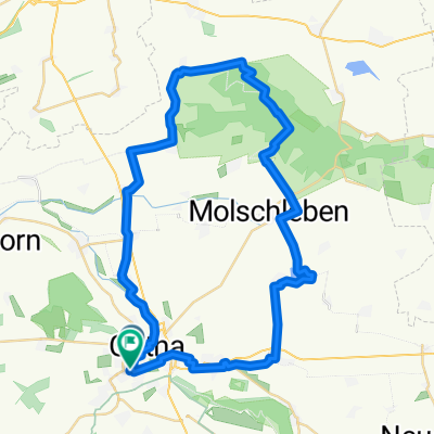
gotha boxberg
A cycling route starting in Gotha, Thuringia, Germany.
Overview
About this route
- 3 h 20 min
- Duration
- 17.1 km
- Distance
- 505 m
- Ascent
- 506 m
- Descent
- 5.2 km/h
- Avg. speed
- ---
- Max. altitude
Route photos


Route quality
Waytypes & surfaces along the route
Waytypes
Track
7.7 km
(45 %)
Quiet road
3.3 km
(19 %)
Surfaces
Paved
11.3 km
(66 %)
Unpaved
4.5 km
(26 %)
Asphalt
9.4 km
(55 %)
Concrete
1.9 km
(11 %)
Continue with Bikemap
Use, edit, or download this cycling route
You would like to ride gotha boxberg or customize it for your own trip? Here is what you can do with this Bikemap route:
Free features
- Save this route as favorite or in collections
- Copy & plan your own version of this route
- Sync your route with Garmin or Wahoo
Premium features
Free trial for 3 days, or one-time payment. More about Bikemap Premium.
- Navigate this route on iOS & Android
- Export a GPX / KML file of this route
- Create your custom printout (try it for free)
- Download this route for offline navigation
Discover more Premium features.
Get Bikemap PremiumFrom our community
Other popular routes starting in Gotha
 Rund um Gotha (Süd-West)
- Distance
- 29.4 km
- Ascent
- 189 m
- Descent
- 176 m
- Location
- Gotha, Thuringia, Germany
 Brieglebstraße, Gotha nach Friedensstraße, Hörsel
- Distance
- 11 km
- Ascent
- 79 m
- Descent
- 63 m
- Location
- Gotha, Thuringia, Germany
 Waltershäuser Straße, Gotha nach Waltershäuser Straße, Gotha
- Distance
- 48.7 km
- Ascent
- 384 m
- Descent
- 382 m
- Location
- Gotha, Thuringia, Germany
 Von Gotha bis Hörsel
- Distance
- 44.6 km
- Ascent
- 381 m
- Descent
- 379 m
- Location
- Gotha, Thuringia, Germany
 gotha boxberg
- Distance
- 17.1 km
- Ascent
- 505 m
- Descent
- 506 m
- Location
- Gotha, Thuringia, Germany
 Düppel-Rundfahrt
- Distance
- 23.1 km
- Ascent
- 250 m
- Descent
- 294 m
- Location
- Gotha, Thuringia, Germany
 Gotha - Hörselgau - Gotha
- Distance
- 34.3 km
- Ascent
- 242 m
- Descent
- 245 m
- Location
- Gotha, Thuringia, Germany
 Moderate Montag Track In Gotha
- Distance
- 19.5 km
- Ascent
- 384 m
- Descent
- 380 m
- Location
- Gotha, Thuringia, Germany
Open it in the app